Armenia: Up North and a Turn West

Northern Armenia shares mountains, valleys and history with Georgia, its northerly Caucasus neighbor. This part of the country is well worth seeing and is greener and lusher than the more arid southern regions. This journey continues along the Debed Gorge (starting in the earlier post here: https://www.aerotrekka.com/armenia-silk-road-passes-mongols-migs/) and then heads west to see Gyumri, Armenia’s second city.

Mountain Range, Lori Province

Khachkar Time at the Debed Gorge Monasteries. The Debed Gorge hosts five of Armenia’s most notable churches and monasteries, that were as much medieval military and political as well as religious centers.

Haghpat Monsastery – Saint Nshan Cathedral

Haghpat Monastery’s main cathedral, Saint Nshan, was built in 976-991 and was the first major construction of a complex that included a library, bell tower, refectory and other buildings, that continued into the mid-13th century. Like many religious centers of the time, it was built on high ground – here overlooking the Debed Gorge – originally with a fortress wall.

Haghpat Monastery

Unusually – for ordinarily unpainted Armenian church interiors – and influenced by the Byzantine orthodox, Saint Nshan has a series of frescoes, the largest and best preserved of which are in the apse showing Christ and other religious figures.

The monastery’s library space is still intact, still showing the holes set in its floor for the purposes of hiding books when the next invader swept through. Next to the library is one of Armenia’s most elaborate khachkars – ornate sculpted stones dominated by a cross – the Holy Redeemer, carved in 1273.

The Holy Redeemer Khachkar – 1273

A stand alone bell tower was constructed in the 1240s.

If you have enough time, there is an 8-kilometer hiking trail to Sanahin Monastery https://hikearmenia.org/all-trails/trail/world-heritage-trail. Both Haghpat and Sanahin were the first of Armenia’s monasteries to be granted UNESCO World Heritage status in 1996.

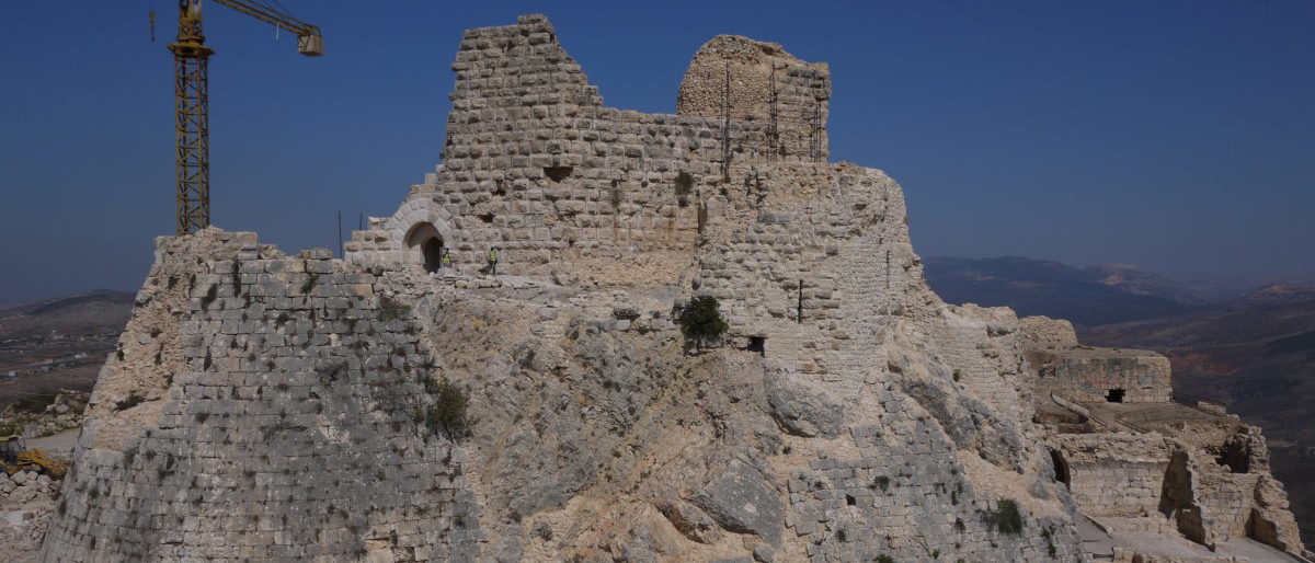
Akhtala Monastery, built on a hillside bluff in the 10th-13th centuries and originally within a fortress, the church is unique in the extent of its luminous and intricate murals; again in a Byzantine orthodox style. Only 10 kilometers from the Georgian border, the Holy Mother of God Church was originally built as a Georgian orthodox church in the early 1200s.

Akhtala Monastery

The dome collapsed in the 18th century and was replaced by a wooden structure. Akhtala is one of the less visited of Armenia’s monasteries, but worth the extra journey on the road to Georgia. The site has superb views into the surrounding valleys but watch your step as there are multiple collapsed subterranean rooms in the monastery grounds.

Holy Mother of God Church

The interior is heavily fresco’ed with biblical scenes and figures of the apostles and saints. The murals are believed to have been painted around 1205-1216 and mostly contain Greek and Georgian script.

Western Wall – Depictions of the Kingdom of Heaven and Various Saints

The apse has a large fresco with a defaced figure of the Virgin Mary and child, and below her a depiction of the last supper and various saints, all overlooking the altar.

Gyumri – the North’s Urban Center. Gyumri is Armenia’s second largest city, and after occupation by the Russians in 1804 during the Russo-Persian War, was Armenia’s principal city until the conquest of Russian Armenia by 1828, where Yerevan was made the capital. Gyumri was renamed Alexandropol – after a Tsar – in 1837 and then Leninakan – after another Tsar – in 1924, only regaining its original Armenian name in 1990. It’s a convenient stop along the northern part of the country, with a Tsarist-era historical center that largely survived the catastrophic 1988 earthquake, which leveled over half of the city. While Gyumri was surpassed by Yerevan as Armenia’s principal city, it is perhaps one of the best preserved examples of Tsarist-era architecture anywhere. Many of the buildings are solidly constructed low-level buildings, some made from black and orange stone found in the region.

Gyumri grew not only as a military and commercial hub for the expanding Russian Empire, but as a refugee center for Western Armenians fleeing the Ottoman Turkish genocide of 1915. The scale of the slaughter was such that orphanages for 22,000 children were established in the city. Historians don’t always look kindly on the Tsarist Russian Empire, but in this case it served a positive role.

All Saviors Church, Gyumri

The December 1988 earthquake was a disaster for the city and surrounding region, killing over 25,000 people and making 500,000 homeless. Gyumri’s main sights are easily walked from the main Vardanants Square – the old town is directly north and Central Park is just west for a greener walk.

Abandoned City Block – South of Central Park

The collapse of the Soviet Union through 1989-91 and the struggle of the restored Armenian Republic’s formative years meant that rebuilding was protracted – in many cases supported by the global Armenian community. Many buildings – Soviet and Tsarist – are still vacant.

Shiraz Street

The historic city center – look for the blocks north of the main Vardanants Square, particularly Abovyan Street – is increasingly restored and is a good place to start your walkabout or evening out.

Abovyan Street, Old Town

The Black Fortress. Gyumri was an important strongpoint in the Russian defenses against the Ottoman Empire to the west and Imperial Persia to the south. In 1837, the Black Fortress was constructed just west of the city. The circular fortress, made of the black stone you see throughout the city, was never attacked but served as a strategic center that was instrumental in the Russian victories over the Ottoman Turks in the 1877-78 war.

The Black Fortress, Gyumri

The walls are heavily carved with Russian and Armenian graffiti. Today, the fort serves as an entertainment venue, with the cannon positions tastefully converted into concert hall style boxes.

Many of the Soviet Republics obtained a memorial to the motherland – here is Mother Armenia, built in 1975, located next to the Black Fortress. This statue holds a wheat sheaf and complements the other Mother Armenia statue in Yerevan, which comes armed with a broadsword.

Mother Armenia, Gyumri

Gyumri Railway Station. In 1899, the Russians connected Gyumri westwards to Kars (then Russian territory) and north to Tbilisi by railway, as part of the Transcaucasian Railway that connected its southern empire. Built in 1979 and an example of late Soviet-era modernist regional architecture, the railway station will connect you efficiently but slowly to Yerevan or as a stop on the way to Tbilisi – and ultimately Batumi on the Black Sea for the beach vacation crowd. The train schedule hasn’t changed much since Soviet times, although links into Russia via and beyond Tbilisi aren’t advertised.

Jrapi Caravanserai. The flatlands southwest of Gyumri run into Lake Arpi, through which the Turkish border runs. Just east of the lake and the H-17 highway is the 11th-century Jrapi Caravanserai, built as a way station between Anatolia and the Caucasus by the Seljuk Turks (https://goo.gl/maps/dkdAUMioZq6pMqhp6). There are two church structures on the site – one in 11th-century ruins and an 1874 building that is active, but usually unattended.

Jrapi Churches with Lake Arpi and Turkey Beyond

Only a quarter of the caravanserai’s roof remains, but there is enough of the remaining walls and archways to see how the full structure must have been. Rather like the Selim Caravanserai (https://www.aerotrekka.com/armenia-silk-road-passes-mongols-migs/), it is a long rectangular building with a single entrance at one end.

Jrapi Caravenserai
Jrapi Church

Logistics. You’ll need your own vehicle to travel around the region efficiently, although if you take the train to Gyumri, the town and the Black Fortress are navigable on foot or with a taxi ride. For hotels, the Tufenkian Avan Dzoreget is a good base to explore the Debed Region and Gyumri has plentiful accommodation – I stayed at the Hay Aspet B&B (53 Shiraz Street – shown as Gorky Street on Google maps, look just east of the Hovnannes Shiraz Museum).

Gyumri has a decent range of restaurant options, serving mainly Armenian food. Some good options include Gyumri Hatsatun (1 Peace Circle – southeast side) and Kilikia Bistro (22 Garegin Nzhdeh Avenue) near the center; in the old town, you can try Florence Gyumri (5/7 Shiraz (shown as Gorky on Google Maps) and Poloz Mukuch (Jivani Street – south of Rustaveli Street). Be aware that Gyumri’s old center is developing so it’s worth taking a walk around to see what else has opened – or closed. The Gyumri Garden House (Abovyan Street, south of Shiraz/Gorky Street) is a popular beer hall and bar and there are a number of cafes along pedestrianized Rijkov Street, with Herbs & Honey (5 Rijkov Street) well recommended. Also popular is Ponchik Monchik, a cafe/snack restaurant located on the west side of Vardanants Square.

Armenia: Silk Road Passes, Mongols and MiGs

Armenia lies on one of the many silk road routes between West Asia and Europe, and has experienced Mongol, Ottoman and Russian influence in addition to its own rule over thousands of years. Taking a route up the center of the country puts you on a silk road route, past Armenia’s largest lake, and into the high plateaus and gorges of the Lori region.

Source: Google Maps.

The Selim Caravanserai. Caravanserais were medieval-era way stations established along the silk road routes to provide safe overnight lodging and provisions for the supply teams. Many were established under the Ottoman Empire and can be seen from the Balkans to the Stans. Armenia has a number of them, the best-preserved being located just south of the crest of the Selim Pass at about 2,400 m. elevation, along the main route between Yeghezhnador and Lake Sevan.

View South from Selim Pass towards Yeghegnadzor

Built around 1332 by Prince Chesar Orbelian – and also called Orbelian’s Caravanserai – it is a long rectangular basalt stone building with a stone slabbed roof. It has a single entrance to a large vestibule on the southeast side, with ornate carvings, including a griffin and a lion, and a lengthy inscription by Chesar dedicating the building in his family’s name and that of Armenia’s Mongol ruler of the time, Busaid Khan. Mongol rule in Armenia was under the Ilkhanate, which included modern-day Georgia, Azerbaijan, Iran and Turkey, and lasted from the mid-1200s until the 1330s, when the Black Death triggered its disintegration. Busaid Khan died in 1335, allegedly poisoned, although plague could have been the cause.

Selim Caravanserai – Entrance

Inside, there is a long central hall, where pack animals were housed and fed, with partitioned spaces off to either side for the merchants and their goods, and skylights to provide some daytime lighting.

This must have been a welcome site for a 14th-century mule train working its way between Central Asia and southeast Europe. Restored in the 1950s, the high degree of preservation was in part possible because of the difficulty in carrying away the building’s stone blocks from such an isolated location.

Lake Sevan. Lake Sevan is Armenia’s largest lake and sole domestic seaside resort. If you are driving over the Selim Pass, you’ll see it as you descend. Heading north, the roads along the west side are most direct and in the best condition.

Passing north through Dilijan, you enter the northern and increasingly mountainous Lori Region. This visit was in late April, so there was plenty of cleansing rainfall.

The Mikoyans of Alaverdi. The post-industrial city of Alaverdi is interesting in part because it shows how Soviet-era industrial activity was jammed into narrow valleys, but also as the birthplace of the Mikoyan brothers – Anastas in 1895 and Artem in 1905. The Mikoyan Brothers Museum (https://goo.gl/maps/HjbGg16i2WD6EjQ69), established in the Soviet era but still very much a source of pride today, is worth a visit.

Alaverdi

Anastas Mikoyan was a Bolshevik revolutionary from 1915 onwards and became a senior Soviet-era politician who joined the Politburo in 1935. A supporter of Stalin, he participated in and survived the purges to become Deputy Premier, involving himself in foreign affairs, before retiring in 1966.

Anastas, Ernest, Translator and a Cocktail Shaker

Artem was an aeronautical engineer who founded the prolific Mikoyan-Gurevich Design Bureau – now synonymous with the word “MiG” for a Russian fast jet aircraft – with Mikhail Gurevich, in 1939. While their early piston-engine designs weren’t successful, their first significant design was the world-beating MiG-15 jet fighter, admittedly powered by the British Rolls-Royce Nene engine. The engine was sold to the Soviets under a license in 1947, which probably ranks as one of the greatest intellectual property and security failures of all time. The MiG-15 went on to shock western air forces in the Korean War.

Needless to say, a MiG gets the top billing at the museum, where a two-seat trainer version of the MiG-21 is exhibited outside. This was one of MiG’s highest production models, that has served since 1959 with over 60 air forces.

MiG-21 Fighter-Bomber, Trainer Version

The museum features memorabilia from two very busy lives and acknowledges the ethical lapses needed for Anastas to survive and thrive as a Soviet politician, particularly during the purges of the 1930s.

Anastas Mikoyan Memorabilia
Artem Mikoyan Memorabilia

Debed Gorge. The Debed River runs north and then northeast from the hub of Vanadzor, past Alaverdi to the Georgian border.

Fans of disused Soviet-era factory buildings will have plenty to look at along the Debed River valley around Alaverdi.

Logistics. I stayed at the Tufenkian Dzoreget Hotel (https://tufenkianheritage.com/en/accommodation/avan-dzoraget-hotel), which is worth a stop in itself for it’s grand building and location next to the Debed River.

Tufenkian Dzoreget Hotel and Debed River

Northern Monasteries. Northern Armenia’s monasteries get less visits owing to their distance from Yerevan but were a very important part of political and spiritual life. In the next post, we look at the spectacular Haghpat and Akhtala monasteries.

Akhtala Monastery Mural

Down South: Armenia’s Mountain Highway

Armenia has a similar area to Belgium but with a very diverse geography, from the Caucasus mountain range that runs along the length of the country, to wine-growing valleys and lakeland beaches. Most visitors head for the regions around Yerevan where you’ll find winter sports and summer hiking. Further southeast takes you along rugged terrain on the road to Meghri on the Iranian border. This route takes you from Yegheghnazdor to the cities of Goris and Kapan, and along the way you have stunning scenery, monastic centers and silk road route towns.

Old and New Goris

Trip 1: Tatev Monastery. Setting out from Yegheghnazdor towards Goris, you’ll get to experience the typical valleys and mountain passes that Armenian road travelers have to deal with. Tatev Monastery sits on the southern side of the wooded Vorotan Gorge.

You’ll turn south off the main M12 highway and head along the northern side of the gorge before crossing the river at Devil’s Bridge and then approaching the monastery up the other side. If you wish to save yourself a hilly switchbacked drive of about 20-30 minutes in each direction, you can stop at the Wings of Tatev cable car (https://tatever.am/en) and take that instead – the view from the 12-minute ride over the Vorotan Gorge is certainly better. Tatev monastery was founded in the 9th century and its main Sts Peter & Paul church dates from around 900. The St Gregory Church was built just south of it around , next to the separate tomb of Saint Gregor Tatevitsi. As with many old buildings in seismically active Armenia, there was extensive damage from a 1931 earthquake, since reconstructed.

Tatev Churches and St. Grigor Tatevatsi’s Tomb

If you have extra time, there is a great 7-kilometer hike between the monastery and Devil’s Bridge, a natural rock bridge over the Vorotan River that runs down the side of the gorge and along the valley floor (https://hikearmenia.org/all-trails/trail/devils-bridge).

Vorotan Gorge

You’ll need to arrange for a pickup at the other end to return to your start point.

Trip 2: Goris. Goris is an excellent town for a stopover. It’s an attractive place that sits in a wider valley area, with the medieval cave city of Old Goris nestled in the cliffsides and conical rock formations to the east of town.

Old Goris

Goris has many well-preserved classic southern Armenian stone houses, many of which are adding their traditional wooden balconies back.

It’s a pleasant town to walk round and the medieval cave dwellings of Old Goris are worth seeing – you can cross the Vararek River via the Garegin Nzhdeh Street bridge and then take a right on Satyan Street to reach the park area. You can use the Hike Armenia app to guide you – https://hikearmenia.org/all-trails/trail/time-travel-to-old-goris.

Kapan’s main Parc de Vienne square and the commercial area just north are popular gathering spots and there are a few cafes and restaurants in the immediate vicinity. You can visit the Aksel Bakunts House Museum (41 Mashtots Street), which is a well-preserved example of a traditional home and an insight into a famous Armenian writer.

Goris Logistics. Goris has a wide range of accommodation and I stayed at the Khoreayi Dzor Hotel, a modern hotel with large rooms and great views over the city – it’s a 20-minute walk to and from the center and there are also good alternatives closer in. Two good restaurants in town are the Wine Garden (65 Syunik Street), which has a large outdoor garden area and is popular for Armenian barbeque, and the Takarik Tavern (65 Syunik Street).

Classic 1960’s Russian GAZ (Gorky Automobile Factory) M-21 Volga automobile, Goris

The Cafe Tur Bazar (end of Grigor Tatevatsi Street), which overlooks the river and medieval cave complex has a good outdoor beer garden and friendly staff – try the local Goris beer, a well made malty lager.

Old Goris

Goris is the home of Armenia’s national quick dish, Jhingalov Hacs, which is a selection of fresh herbs put between fresh lavash bread and griddled. It’s delicious and meets most dietary requirements.

Jhingalov Hacs
Dowtown Goris and Police Station Emblazoned with a Former Soviet Star

Trip 3: Kapan. Kapan is a 2-3 hour drive south through the scenic Goris River gorge and Vorotan River valley. It can be a slow drive with hairpin bends, Iranian trucks and periodic rainy weather and fog. Note that certain stretches of the road lie inside the post-2020 War settlement Azerbaijani border, and that you’ll see (as of 2021) Armenian military and Russian ceasefire observers at certain points.

You can travel through in safety – applying caution for rain, fog and slow-moving trucks – but be ready to stop at the Armenian security checkpoints where they may ask to see your passport and then wave you through. If you use google maps you won’t be routed via this direct southeasterly Goris-Kapan road (and instead sent via Tatev), but ask at your hotel before you set out whether the road is open, which it was in Spring 2021.

Azeri Stretches of the Goris-Kapan Road

Kapan is a grittier working town set in the Voghji River valley, with significant industrial activity from Soviet times. You’ll see a large number of workers’ flats set into the northern hillsides overlooking the town, reflecting it’s importance as a Soviet-era industrial center.

Abandoned Ferris Wheel, Kapan Central Park

Today, it’s an important center for molybdenum mining. The Kapan History Museum (24/41 Garegin Nzhdeh Street) is worth a visit, and records the history of the 1994 Nagorno-Karabakh War, as well as the participation of Kapan’s citizens in WW2. There’s also good recording of Kapan’s development since the 19th century and as a mining center.

Kapan’s WW2 Veterans – Kapan History Museum

There are some good side trips possible from Kapan. If you’re a determined driver, you could go on to Meghri, 72 kilometers away on the Iranian border.

Russian FSB Ceasefire Patrol Vehicle, Kapan

Vahanavank Monastery is worth a look – just 10 minutes west of Kapan along the Meghri Road, this 11th century church was built by the Queen of Syunik.

Another more ambitious outdoor objective is Mount Khustrup, which can be accessed via the Baghaburj area of Kapan or via Navcha https://www.alltrails.com/trail/armenia/syunik–3/mount-khustup.

Kapan Logistics. Kapan has a few hotels in the center, and the Dian Hotel, a 15-minute walk just east of town, is modern and well-run. Cafe Elegant (32 Shahumyan Street) and Tumanyan’s (Shahumyan Street roundabout just east of Cafe Elegant) are popular restaurants. A good shwarma cafe is located just west of Cafe Elegant on the opposite side of Shahumyan Street.

Yeghegnadzor: Armenian Highlands, Hilltop Fortresses and Wine

The town of Yeghegnazdor is the capital of the central Armenian province of Vayots Dzor, a winemaking region and a good travel base south of Yerevan. Central Armenia has plenty of rugged terrain, and the roads get windy. At this point, it was worth hiring a vehicle to get about. Yeghegnazdor is less than a day’s drive from Yerevan and there’s plenty to see along the way.

Trip 1: Monasteried Out. Heading south towards Yeghegnazdor from Yerevan, you can hit up the historical sites of Khor Virap, the Garni Temple and Geghard Monastery, finishing up in Yeghegnazdor for the evening. These are all day-trip distance from Yerevan, so are better seen early in the day and best avoided over weekends, but nonetheless worth checking out. The Khor Virap (Deep Dungeon) Monastery is worth seeing in part because of its location in the plains east of Mount Ararat – arrive early because Ararat clouds up through the day. You want to catch it in the morning when it’s year-round snowy peak floats above the cloud line.

Mount Ararat and Lada Niva 4×4

Garni Temple. Heading southeast from Yerevan, the first stop is the Garni Temple, a Roman-era basalt temple originally constructed in about 170 AD in memory of the Romanized ruler of the Province.

It sits above the Azat River Valley and is co-located with a 7th-century Christian church. Demolished by an earthquake in the late 17th century, it was only restored in the early 1970s.

Azat River looking East

Geghard Monastery. Further east, you can also see the Geghard (Spear) Monastery, another iconic Armenian religious center, partly built into the cliffside and with cave dwellings and rock-hewn chapels in the cliffs above the complex. Founded in the 4th century around a Spring overlooking the Azat River gorge, the main chapel was built around 1215. There are active churches within the walled monastery complex, with the main Katoghike Chapel quite busy on a Sunday.

Katoghike Chapel Vestry

Khor Virap. The Khor Virap monastery was the place where Gregory the Illuminator, the first leader of Armenian christianity, was imprisoned for 12 years before he began converting the monarchy and population to Christianity. You can visit his 3rd-century dungeon – grab the safety line and take it carefully down the stairs. The current buildings are more recent, from around the 17th-century. It’s better to go early in the day to be able to see Mt. Ararat, just over 30 km to the west, before the peak clouds over.

Khor Virap

Trip 2: Yegheghis Village and the Jewish Cemetery. Armenia is located in a tough geopolitical neighborhood with challenging mountain terrain. The village of Yeghegis is located in the verdant Yeghegis River valley, a state wildlife sanctuary, and has been settled for thousands of years. The original medieval town is closer to the river than the current town and has one of the oldest known Jewish cemeteries from around the 13th-15th centuries. It has a cluster of churches, notably the Zorats (Army) Church just east of town, built in 1303. It has a terraced outdoor gallery so that arms and horses could be blessed before battle, along with their riders.

Zorats Church

If you head just east of town and take the first right-hand vehicle track, you go south towards the river and cross it on the footbridge that leads to the medieval Jewish cemetery (https://goo.gl/maps/yw1NcpwTYDQmUJJX8). Believed to be one of the oldest Jewish cemeteries identified outside the Middle East, there are about 60 medieval headstones from a period when the region was ruled by Mongol and Turkic invaders. Many of these are elaborately ornamented and inscribed.

Yeghegis Jewish Cemetery

Yeghegis village can be a prelude to the next trip, but it makes for an ambitious day.

Trip 3: The Smbataberd Fortress and Tsakhats Kar Monastery Hill Hikes. This is an approximately 4-5 hour out-and-back hike that takes you to the impressive hilltop fortress, named after Prince Smbat, the regional ruler of the time, and then via a high meadow to the monastery, which is about 2 kilometers east of the fortress via a vehicle trail. As also used here (https://www.aerotrekka.com/armenia-hiking-the-caucasus/), the trusty HIKEArmenia.org website and app provide a useful downloadable hiking map. https://hikearmenia.org/all-trails/trail/tour-through-wine-country

Smbataberd Fortress Looking South

Smbataberd Fortress. You can either start this trail from Yeghegis Village to the south, or approach from the next valley over, from the west, via the village of Artabuynk – you’ll see the hiking app displays both approach routes. I visited Yeghegis Village first, left my Lada Niva safely parked in the center and took the gradual path up to Smbataberd, which you can see from the start of the trail.

Yeghegis Village from Smbataberd Fortress

Once you’re at Smbataberd, for which the outlines of the outer walls, entrance tower, keep and certain inner walls remain, you can see how this dominated the valleys off to either side of its clifftop redoubts. Largely built by Armenian rulers around the 9th-10th century, the fortress was lost to invading Seljuk Turks in the 11th century, with the legend that a thirsty horse discovered the water pipe supplying the fortress – leading down from the monastery – which was then cut.

Smbataberd Fortress looking northeast towards Tsakhats Kar Monastery

Tsakhats Kar Monastery. After checking out the fortress, and wondering how anyone moved around these hills with medieval military equipment, you then head northeast down the vehicle track into a meadow – grazing cattle may be around – and then up the hillside towards the windswept Tsakhats Kar monastery complex, almost 4 km northeast.

Tsakhats Kar Monastery

This consists of two chapels built in the 11th century; the eastern Holy Cross and western St. John the Baptist churches. The monastery complex has great views looking south and over Smbataberd and has elaborate carved designs on its facade and on the standing stones (khachkars).

St. John the Baptist Church
Holy Cross Church

A large ruined monastery building is located along the road track about 150 meters west of the two churches, with an intact doorway, front wall and standing archways. This appears to have been built between about 1000 and 1200, and would have been a substantial center for the time, notable for being in such an isolated spot. The weed-filled open area inside the walls is filled with stones, khachkars and a water trough.

Logistics. I stayed at the Green Stone Hotel (https://goo.gl/maps/3QbhQDmNP5kDGTsy8 2, 5, Gladzoryan Lane), which is a new and very comfortable small hotel, equipped with a garden and swimming pool. Food options in town are mainly via the local hotels and B&Bs, which are very high quality with plenty of fresh local produce. You should try to book dinner the day before.

Green Stone Hotel Balcony

The Green Stone Hotel has great catering, and the Old Bridge Winery (https://www.oldbridgewinery.com) offers an extensive Armenian set menu with their own wines. A good casual option and popular stopoff is the Food Court, which offers a typical Armenian menu and is located on the Yerevanyan Highway heading southeast just out of town (https://goo.gl/maps/oSrWVvr5252myBMu6).

Wineries. You should do your winery research before you go. Armenia and Georgia have a healthy debate as to who has the oldest winemaking tradition, although Armenia’s wine industry is at a smaller scale given that many vines were given over to brandy production in the Soviet era. There are nonetheless plenty of quality wineries that focus on some of the 31 wine grape varieties found in Armenia, like the Areni (red), Kangun (white) and Voskehat (white). Vayots Dzor hosts the annual Areni Wine Festival every May and there are plenty of nationally recognized wineries in the valley, including Hin Areni, Momik, Trinity Canyon, Yacoubian and Zorah.

Car Hire and Roadways. Your car hire choices are mainly located in Yerevan. I went with one of the local providers, Car&Van (https://www.caravan.am/en-home.html), who usually have the option to hire a Lada 4×4, pictured earlier in front of Mt. Ararat. The Lada lacks the comforts and ergonomics you usually expect and is a dated design with an upper speed limit of about 80-90 km/h. However, the suspension and clearance are well suited to many of Armenia’s roads, particularly outside and south of the Yerevan area. Once you’re clear of Yerevan, specifically when you turn off the main H8 highway to head east to Yeghegnadzor, nearly all roads are single-lane each way and degraded in places, so figure on a typical road speed of between 50-80 km/h.

Winding Roads and Iranian Tanker Trucks

Armenia’s sole north-south road between Yeghezhnador and the Iranian border at Meghri runs through the towns of Goris, Kapan and the hill ranges and associated hairpin bends along the way, so it’s a careful drive along with the Iranian lorries. Given the incidence of potholes and roadworks, you should avoid driving in the dark.

Tsakhats Kar Monastery Entrance

Armenia: Hiking the Caucasus

Armenia has wild and wonderful hiking country that is easily reached from its capital, Yerevan. You can start by heading to the resort town of Dilijan, a 90-minute drive away in the hills north of Lake Sevan, Armenia’s largest lake and the closest thing to a beach destination that a landlocked country has. Many of the hikes combine superb scenery with historical sites not easily accessible to most visitors, along with some substantial elevation changes.

You can plan your hikes and download the trail map using the HIKEArmenia app. HIKEArmenia are a non-profit organization that organize and map out treks of varying difficulty around the country. Check out their website at https://hikearmenia.org and download their app. You can download the trail maps before each hike and use them offline – make sure that your phone is fully charged before heading out!

Hike 1: The Jukhtakvank – Matosavank Monasteries Loop. This is a good shorter hike that can be done in 3 or so hours. The app has you start walking from Abovyan Street, which is the main road (and then track) that leads past the mineral water plant to Jukhtakvank from the M8 highway. The monasteries are on different sides of the same river valley, so you get a hilly forested hike with a couple of river crossings thrown in. I started at Jukhtakvank and looped counterclockwise to Matosavank. Both the monasteries were built off trails leading up from the valley floor, amid forests that still stand today.

Jukhtakvank was built around 1200 and became an important religious community centered around its two chapels, one of which, St. Gregory’s, has elaborate wall carvings.

There are cattle grazing in the valley so watch out for them, and make sure to follow the app trail closely as there are multiple trails in the valley. Matosavank, named after St. Matthew, is a larger, L-shaped single building from the 13th century, built into the hillside, with a collapsed cupola off to one side.

At the end of the trail leading down from Matosavank to Abovyan Road, you’ll have to cross the river by a small footbridge. There is a rest area and water point with gushing spring water, topped with a memorial stone.

The trail link is here: https://hikearmenia.org/all-trails/trail/medieval-monasteries-trail You can access the trail start easily by taxi; there as a bus stop at the village on Abovyan Road, or you can simply walk to and from Dilijan which is about 6 km from Jukhtakvank.

Hike 2: Dilijan National Park from Haghartsin Monastery to Jukhtakvank Monastery. This is an all-day approximately 20-kilometer / 6-8 hour hike that takes you along the passes and ridgelines north of Dilijan. https://hikearmenia.org/all-trails/trail/360-dilijan

It’s an A to B hike and the best way to get to the start is a 20-minute taxi ride to Hagartsin from Dilijan. You can absorb the historical vibes around the Hagartsin Monastery complex, which sits at the top of a valley leading up from the Dilijan road. This is a larger complex with five churches or chapels and a refectory, built in the 10th-13th centuries; it’s a popular attraction so an early start is good to avoid the crowds and get going on the hike.

You’ll start up a fire trail that puts the monastery below you in its valley setting. The start point just north of the monastery is signposted for Jukhtakvank, and there are periodic red/white painted markers on rocks. The route is mostly on well-defined walking and vehicle track, but is hard to follow in places, so have the HIKEArmenia trail map downloaded from the app before you set out. Check the weather before you go and prepare for the mountain weather – while you aren’t up around the peaks, dependent upon time of year, you can get weather fronts moving through.

Much of the trail crosses high meadows stretching along the hillsides, interrupted by some climbs over passes. There are a series of small farming communities along the route, often with the herds out grazing the hillsides.

For much of the trail route you can keep the Dilijan area main valley in sight on your left side. As you complete the route into Jukhtakvank, you’ll descend into farmland and forested trails. Watch out for the farm complex about 1 km from the end – the dogs are quite verbally aggressive; although their bark looks to be worse than their bite, and a swing from the daypack keeps them away.

Other Wanderings. The hiking app offers other trails, including short hikes in the forested hills around Dilijan. Another destination hike offered is to start at Lake Parz (get a taxi out there), a popular local destination, and hike back into town. In addition to the fairly small restored old town, there are also other local sights, including an abandoned Soviet-era hotel overlooking the city lake.

Further up the hill overlooking the lake from the south is the abandoned Khanjian Villa (https://goo.gl/maps/xqEzZh2YhNFcNfiM6), built on the orders of Aghasi Khanjian, the First Secretary of the Armenian Communist Party in the 1930s, who allegedly committed suicide on a trip to Moscow in 1936, but was likely assassinated in a power struggle or as part of the purges of the time. Opened in 1937, the villa was later used as a government rest house but left to ruin after the collapse of the Soviet Union. The google map location is best accessed on foot via Maxim Gorky Street – the main road that heads south out of Dilijan – and taking the second road on the right after you go past the lake.

Logistics. Dilijan is a very walkable town that is used to accommodating travelers, and has good B&B and catering options. There is a lower town based around the main roundabout (where the bus stop is), and an upper town that has a traditional restored old town area along Sharembayan Street, and the main commercial center further east.

I stayed at the Toon Armeni Guesthouse (Kamarini 4) which overlooked the upper town center, and was a 5-10 minute walk from most of Dilijan – pleasant simple rooms with a porch, a view over the valley and a good breakfast to set you up for a day’s walkabout.

You can move independently to/from Dilijan without needing a hire car. Minibuses depart to and from Dilijan center via the Yerevan North Bus Station and timings are online at the excellent https://t-armenia.com/en website. Alternatively, you can get a taxi one-way from central Yerevan for about $20. I used the YandexGo app, which was excellent for taxi rides of any distance, including around Dilijan. The app won’t take US/European credit cards, so you just pay the quoted cash amount. There are plenty of good restaurants in town – Haykanoush (Sharambeyan Street), run by the Tufenkian Foundation, is a good traditional bet, and the Kchuch Restaurant (Myasnikyan 37) has traditional Armenian stews and barbeque as well as pizza. The Carahunge Cafe (Kalinini 25) has a good Armenian menu and is one of the few places in town that’s also set up more as a bar/cafe.

A good local post-hike amenity is the Russian-style beer stand (look for the “пиво” sign) located close to the Mimino character statues (after the popular Soviet-era movie that had Armenian and Georgian lead characters) on the west side of the main roundabout. The staff are very friendly and while they usually sell in 1-liter containers for takeout, if you want to get some glasses to take to sit by the nearby boating lake, just ask. They have a range of typical Armenian lagers – Gyumri being the highest quality, as well as the excellent range of Dargett craft beers.

Memphis to the Sea – Part 1

The United States is more a continental federation than a country. Mississippi is a different place to California. Rather like asking a Norwegian why Hungary is a certain way and expecting them to have a deep insight because they are all Europeans, it seemed to be a good time to get a bit smarter about other places and go visit fellow Americans down south.

THE ROUTE

Memphis, Tennessee was the start and finish point, with a counter-clockwise route following the Mississippi south to Vicksburg and Natchez, cornering at Lafayette, Louisiana, before stopping on the Gulf coast at Biloxi and Ocean Springs, Mississippi. Then up to Oxford, Mississippi and finally back to Memphis.

Source: Google maps, 2020.

MEMPHIS

Memphis grew as a trading hub on the Mississippi River and as a large urban center for western Tennessee and the surrounding states.

It’s a mid-size town with many cultural identifiers as the center of the Memphis Blues, and the home of the Civil Rights Museum. Elvis lived here and a visit to Graceland is worth the 2-4 hours that the tour takes. You’ll really need a car though – the downtown is quite small and while Beale Street is worth a look as the cradle of the Memphis Blues, it’s been touristified and most other locations are a bit dispersed. I stayed east in the Midtown area. The airport is just 10 miles from the city center and easy to use. A few places to see include:

National Civil Rights Museum (450 Mulberry Street). Located on and built around the Lorraine Motel, where Martin Luther King was assassinated in April 1968, this is well worth visiting to understand the civil rights struggle in the US.

It’s quite extensive and mostly focuses on the postwar period through to the 1970s, and you should allow at least 2 hours.

The museum features exhibits about the Green Book, a travel guide published in Harlem between 1936 and 1966 so that African-American travelers could avoid discrimination and violence, and find a welcome place along their journey.

Stax Museum of American Soul Music (926 E McLemore Avenue). Stax Records was the pre-eminent soul record label in the 1950s-1970s, and the museum explains how musicians in the Memphis area gathered in gospel, blues and country influences to produce a unique sound that complemented other regional sounds such as Motown and Nashville. The other major Memphis label, Sun Records, founded by Sam Phillips in 1952, was famous for discovering the likes of Elvis Presley and Johnny Cash, but moved to Nashville in 1969.

Graceland (Elvis Presley Boulevard). Elvis Presley’s mansion and accompanying personal aircraft. Allow at least two-three hours for the organized tours and book ahead online at https://www.graceland.com. You can also stay at the affiliated guesthouse for the full Elvis experience.

Eating Out. Not surprisingly BBQ and hot fried chicken are two staples worth checking out, although there are plenty of more contemporary takes on southern cooking.

Central BBQ – traditional local mini-chain, downtown (147 E Butler Avenue) and midtown (2249 Central Avenue).

Arnold’s BBQ and Grill (337 Madison Ave #2).

Hattie B’s Hot Chicken – classic fried chicken, in the midtown (596 Cooper Street).

Gus’s World Famous Fried Chicken – one of the originals, downtown (310 S Front Street) is usually busier than the east Memphis (730 S Mendenhall Road) branches and both are excellent.

Craft Beer. Memphis has some good craft beer options, mostly around the downtown area.

Ghost River Brewery & Taproom (827 S Main St, Memphis, TN 38106)

High Cotton Brewing Company (598 Monroe Avenue)

Memphis Made Brewing Co. (768 Cooper St), located in the Cooper-Young district.

Wiseacre Brewing Company (main taproom at 398 South B.B. King Boulevard and also for East Memphis at 2783 Broad Avenue).

The Mississippi Delta Cottonfield Country

Driving south towards Vicksburg along the east side of the Mississippi, you’ll pass through cottonfield areas – requiring substantial irrigation hence their location close to the river – that are now industrial farms. This was a major center of the slaver agricultural economy and to this day, towns like Clarksdale and Greenfield are still quite poor – Mississippi takes turns with West Virginia to have the lowest average per capita income in the Union. This is also the home of many blues and gospel artists and Clarksdale is worth a stop to see the Delta Blues Museum (1 Blues Alley, Clarksdale) and take a wander round.

The center has a rundown air to it, common to many smaller towns that peaked in the postwar period but then depopulated or suburbanized. Clarksdale and the surrounding area saw substantial outward migration as agriculture mechanized in the mid-20th century and urban centers such as Chicago offered better opportunities.

There are various memorials to musicians, such as Sam Cooke, who grew up here but left, or Ike Turner, who was also a local DJ, as well as the infamous but now workaday crossroads (North State Street and Desoto Avenue) where Robert Johnson allegedly sold his soul to the devil in exchange for his musical talent. The Mississippi Blues Trail website is worth visiting to see who did what and where: http://www.msbluestrail.org/delta

Abe’s Bar-B-Q is located on the southeast side of the crossroads at 616 N State if you’re there around lunchtime. A good place to stay is the historical Riverside Hotel, which as an African-American owned hotel accommodated many musicians in the day. http://www.riversideclarksdale.com

Vicksburg

Vicksburg, located on a hilly overlook of the intersection between the Yazoo and Mississippi rivers, is a good place to stay for a day, and a visit to the Civil War battlefield park just east of the city is well worth it. A major market center for the cotton economy, it was fortified by the Confederacy and heavily shelled during siege by Union forces in 1863. Subsequently rebuilt with a residential and downtown core from the late 19th and early 20th centuries, it’s walkable and attractive. You’ll find a set of historical buildings in town, including the 1863 siege headquarters of the Confederate General Pemberton (1018 Crawford Street) and the postwar railroad terminal (1010 Levee Street), by the river, also the site of the local battlefield museum (http://www.vicksburgbattlefieldmuseum.net).

Washington Street has most of what you need for an evening out, including craft beer (Cottonwood Public House, 1311 Washington) and few southern cooking options (Rusty’s Riverfront Grill, 901 Washington and 10 South Rooftop Bar & Grill, 1301 Washington). I stayed at the Duff Green Mansion (1114 1st E Street), which has a preserved antebellum-era interior.

The Vicksburg National Military Park (3201 Clay Street https://www.nps.gov/vick/index.htm), just east of the city, covers most of the battlefield sites of the Union attack and siege of Confederate Vicksburg in 1863. Grant’s first major victory, the conquest of Vicksburg on July 4, 1863, robbed the Confederacy of control of the Mississippi River and split the southern states apart. Founded in 1899, the park covers specific battle sites and fortifications are identified, along with monuments installed by States and veterans of both sides after the war.

The Confederate monuments – mostly installed at the turn of the 19th century – are oblivious to the misery that slavery caused, or the fact of their treason. The park is best accessed by car and there are parking areas along the route so that you can get out and walk the main areas. You can also download the battlefield app (https://www.battlefields.org/visit/mobile-apps/vicksburg-battle-app) which supplements the rather handy park map.

The battlefield’s preservation less than 40 years after events kept many of the features from development and you can understand what it must have been like to make a frontal attack on a well-entrenched enemy.

You’ll enhance your experience and help the park if you hire a guide via the park website. It’s worth seeing the USS Cairo (3201 Clay Street), a recovered and partially restored Union Navy steam-powered ironclad that bombarded Vicksburg and is now housed in an open air shelter.

Vicksburg is surrounded by other smaller battlefield memorials. The campaign consisted of multiple attempts to force the city, including the futile Battle of Chickasaw Bayou, where General Sherman’s force of 9,000 attacked from a bayou against a Confederate fortification and were thrown back with heavy loss of life. Port Gibson, about 20 miles south of Vicksburg, was the scene of a holding action by the Confederates as the Union forces advanced north from their landing grounds.

Natchez

Natchez was founded in 1716 as a French fort and trading post on a bluff overlooking the Mississippi. It was the southern river hub for the Natchez Trace, a trail that linked the Mississippi with settled colonial-era regions in the southeast, that ran through to Nashville.

Natchez grew as a port and urban center for the Southern agricultural economy and is dotted with former slaveholder mansions. It surrendered in 1862 and avoided the damage inflicted on Vicksburg. Today Natchez is a sedate, well-preserved Victorian-era town, although the lower town on the banks of the river once had a seedy dockside reputation.

There are a couple of decent bar/restaurants, including The Camp, which has a good food and craft beer menu, and the more atmospheric Under-the-Hill Saloon (21 and 25 Silver Street). The Natchez Brewing Company in the main town (207 High Street) is worth a visit for local beer.

Natchez is a good overnight stop; as with many southern towns, there was a violent civil rights struggle in the 1950s and 1960s, that is memorialized outside the City Hall and in the Museum of African-American Culture (301 Main Street). There are various preserved antebellum homes in town and a city trail that overlooks the river. I stayed at the Guest House Mansion Inn (401 Franklin Street).

Weekend in Provence: Part Un

If you only have a few days in the South of France, Marseille – France’s second biggest city and gateway to the Mediterranean – is a good place to start. Marseille is a gritty, lively southern city that looks out to France’s former North African territories as well as to its Roman maritime and trading past. A hotbed of revolutionary activity in the late 18th century, the rather aggressive fighting song that later became France’s national anthem, the Marseillaise, was written here. Despite this, Marseille doesn’t attract many tourists, so you can largely wander around unhindered. The old port (Vieux-Port), now an oversized marina and a place for a few fishing boats to sell their catch, is a good place to get oriented. Take a break beneath the Norman Foster-designed polished steel canopy on Quai des Belges, that reflects the crowd beneath it.

IMG_20200313_184357

Marseille Vieux-Port, Quai des Belges and L’Ombrière de Norman Foster

The Vieux-Port is a large harbor protected by twin fortresses, Fort Ganteaume on the south entrance side, still owned by the military; and Fort Saint-Jean on the north side, which serves as an annex to the recently built Mediterranean museum and as an overlook to the port and city. You can also walk west past Fort Ganteaume out to the Pharo and Emile Duclaux Park, located on a headland just seaward of the twin forts, to get some fresh sea air.

IMG_20200312_154513

Marseille Vieux-Port and Fort Saint-Jean from the Pharo

Military Marseille would have been a hard nut to crack as the view between the harbor entrance forts shows. If you are in the mood for more of Imperial France’s castles, you can take the short ferry ride to the Chateau d’If, an island fortification guarding the city approaches and the setting for Alexandre Dumas’ novel, the Count of Monte Cristo. The top of Fort Saint-Jean is now a network of promenades and gardens overlooking the Marina and the city, and a nice way to get away from the bustle of the city.

Fort Saint-Jean looking towards the Notre-Dame de Garde basilica.


IMG_20200314_085357

Marseille Vieux-Port, Quai des Belges

Within the old city around the port, there are various grand and buttery yellow 19th-century buildings constructed as Marseille developed as France’s gateway to the Med, including the local bourse.  Commemorated just opposite is the place in 1934 where King Alexander of Serbia was assassinated right off the ship by a Macedonian nationalist, while visiting to sign a strengthened alliance with France against Fascist Italy. Now largely forgotten, it was considered a disaster at the time with recent enough memories of the 1914 Sarajevo assassination; Alexander’s assassination presaged the political instability of the 1930s.

IMG_20200313_101618

Marseille Bourse and King Alexander Memorial

The Museum of Civilizations of Europe and the Mediterranean (MuCEM) is worth visiting for its exhibits but also as an interesting modern architectural artifact from which you can cross a footbridge to Fort Saint-Jean. The shaded rooftop deck of the MuCEM has a cafe and public seating areas with a view over the harbor entrance.

MuCEM with Cathedral la Major behind

Otherwise wandering the streets around the Old Port gives you a good feel for the place as a Mediterranean hub. There’s an outdoor market along Rue du Marche des Capuchins that is worth a look.

Market Area, Rue du Marche des Capuchins

Market Area, Rue du Marche des Capuchins

You can also catch up on your intense graffiti art fix courtesy of the protesting Gilets Jaunes, much of which is around the Cours Julien park.

Rue Pastoret Graffiti

Escaliers du Cours Julien

Other places worth a visit include the Marseille History Museum (2 Rue Henri Barbusse), which takes you back to Greek and Roman times, and for your traditional art fix, the Palais Longchamp park area contains the Musee des Beaux Artes (9 Rue Eduoard Stephan). Marseille was still quite busy up until the closure of public places on March 14 – as a southern European city it has a lot of outdoor venues that were up and running in brisk Spring weather.

For an evening out, a couple of areas to head for include the area around the park centered by Le Cours Julien (and more generally inside the triangle formed by Rue Saint-Pierre, Cours Lieutaud and Rue des 3 Freres Bartelemy), east of the Vieux-Port; and the area along Rue Sainte, just south of the port. Cours Honoré-d’Estienne-d’Orves is another large open area just north of Rue Sainte with a lot of cafes. The crowds were out on the last weekend before the Government shut public venues and you can see why there was needed in March 2020.

IMG_20200312_185805

Cours Julien

Cours Honoré-d’Estienne-d’Orves

IMG_20200313_184228

Quai des Belges, Vieux-Port

Logistics. I stayed at the Alex Hotel, just west of the Saint-Charles railway station at 13-15 Place des Marseillaises. Saint-Charles railway station serves both local and inter-city destinations, and has plenty of self-serve ticket machines in the main entrance. If you arrive via the airport, the most efficient public transit route is the airport bus which travels the 25 kilometer distance to Saint-Charles non-stop – turn immediate left after leaving the passenger terminal and head straight for the bus terminal and ticket office. Marseille has a metro system (the nearest to the airport at Vitrolles station), although much of the main area is walkable.

It’s France so eating out can be readily researched. I had good luck in the Cours Julien area with La Resto Provencal (64 Cours Julien); around the western side of Rue Sainte with La Carrousel (139 Rue Sainte) and around the Cours Honoré-d’Estienne-d’Orves square area with the more traditional Les Arcenaulx (25 Cours Honoré-d’Estienne-d’Orves). Not surprisingly there are multiple places offering bouillabaisse, a saffron- and garlic-infused seafood stew, which is worth a try – Resto Provencal and Les Arcenaulx do. Le Bistro Bleu (20 Rue Jean François Leca) is a busy lunch spot with good regional menus, just north of the MuCEM in the newer part of town northwest of the Vieux-Port.

Craft beer-wise there are a range of good options that feature regional breweries. Starting west, the area around Rue Sainte and Rue Robert features Victor, a brewery (20 Rue d’Endoume), Le 143 (143 Rue Sainte). Further east and just south of the Vieux-Port is he Marseille branch of the popular Les Berthom chain, which has a good Belgian selection (31 Cours Honoré d’Estienne d’Orves). In the busy Cours Julien area, try La Voie Maltée (7 Rue Crudère), Beer De La Plaine (16 Rue Saint-Pierre) and facing the square, the cavernous Brasserie Communale (57 Cours Julien). 

A good coffee/snack venue is La Boutique du Glacier (1 Place Général de Gaulle), and another southern specialty – pissalidiere, an anchovy, olive and onion tart, is great there.

Cassis and Massif des Calanques Sidetrip. Cassis is a good day trip out of Marseille, either to hit the beach or go hiking in the nearby national park. Only 30 minutes on the train from Marseille Saint-Charles station, Cassis’ railway station is however a 30-minute walk into town, which is pleasant enough along the vineyards. Alternatively, the regional bus will drop you slightly closer in.

IMG_20200314_145431

Vineyards outside Ciotat

Apart from wandering the rather touristy waterfront and the back lanes of this little town, there are also a few beaches just outside. Cassis gets plenty of mostly regional visitors so there are plenty of cafe and restaurant options.

IMG_20200314_140327

La Ciotat Harborfront

More ambitiously, you can hike in and explore the calanques, a series of narrow white limestone inlets along 20 kilometers of coastline, located in the Massif des Calanques national park. You could manage a decent half- to all-day hike along mostly shaded cliffs overlooking the ocean, or spend more time making forays into the park from a base in La Ciotat. There is also a youth hostel in the park. Either way, on the way out of town you first pass the Plage du Bestouan, situated just west of the harbor entrance. This is a good place to drop people who prefer the beach to a hike.

IMG_20200314_110634

Plage du Bestouan

From Plage du Bestouan, you’ll head to Avenue de Calanques and enter the park at the head of the Calanque de Port-Miou, which is the first in the series and unlike the others is somewhat developed, with a marina.

Calanques National Park – Southeast Area                                                                Source: Google Maps.

The nearest calanques accessible in a part-day hike are Port-Miou, Port Pin and d’en Vau. Both Port Pin and d’en Vau have beaches at the base of the calanque.

Calanque de Port-Miou

The trails to the Calanques hug the coastline and are well-signposted, consisting largely of sand and stone with a fair amount of vertical involved – take hats, sunblock and water (there is none once on trail) and the views are spectacular. There are some steep inclines so running or trail shoes with some traction are recommended.

IMG_20200314_115251

Calanque de Port Pin

IMG_20200314_115024

Calanque de Port-Miou

Beach at Calanque de Port Pin

In addition to exploring the coastline, there is also an extensive inland trail network, with one scenic objective being Mont Puget, which at about 1,850 feet elevation offers great views of the park and the Mediterranean.

IMG_20200314_121851

Trails above Calanque d’en Vau with Ile Riou beyond

IMG_20200314_112907

Calanque de Port-Miou

IMG_20200314_105752

Port Cassis

The Latvia Loop

Latvia is the central of the three Baltic states, bordered by Estonia to the north, Lithuania to the south and Belarus and Russia to the east. From Riga, you can go west and take in the historical fortress and market town of Kuldiga, the busy seaport of Ventspils, and the seaside town of Liepaja – with its previously secret Soviet naval base – in a manageable loop drive of about 500km in total. This western part of Latvia – Courland or Kurzeme to the Latvians – was originally ruled by the pagan Baltic Curonian tribe, who were conquered by the German military orders active in the medieval Baltic States. This later became the Duchy of Courland, part of the Duchy of Lithuania, and was later annexed by Tsarist Russia in 1795. Many of the cities were part of the Hanseatic League, which you can read about here https://www.aerotrekka.com/full-hansa-lubeck-rostock/. Start your trip in Riga and head past its own seaside town of Jurmala west towards Kuldiga.

fullsizeoutput_56c.jpeg

Source: Google Maps.

Kuldiga

Kuldiga owes its start in the 1240s to the development of a fortress overlooking the River Venta, which provided connections to other rivers while being a short distance to the coast. The river is traversed by a 19th-century brick bridge – one of the longest of it’s type – that is the venue for traditional midsummer night running races. Just upriver from the bridge is a set of rapids, evocatively referred to as the Ventas Rumba.

The city joined the Hanseatic League in 1368 which gave connections throughout the Baltic and Eastern Europe. The Aleksupite River runs through town and to match the midsummer night runners over the Venta Bridge, has another annual race where the runners go along the river bed.

IMG_20191216_144736

The eastern part of town overlooking the river and the Ventas Rumba has a large set of mounds on which the fortress and associated medieval buildings – including a convent – stood until their destruction in the great Northern War with Sweden in 1702. It’s now a rolling park adjoining the river, populated with stone sculptures by Livija Rezevska, a Latvian artist. The city museum (Pils Iela 5)(https://www.kuldigasmuzejs.lv/eng), in a manor house by the river, is worth checking out.

IMG_20191216_152416

The town itself lies further west and was developed later in the 17th-20th centuries after a major fire consumed earlier wooden structures.  It’s a good place to stop off on your way to Ventspils or Liepaja from Riga, to grab lunch around the main square at Baznicas Iela and have a wander round. Kursas Zeme (Baznicas Iela 6) is a good cafe or if you want the cellar experience try Pagrabins (Baznicas Iela 5).

IMG_20191216_154233

Kuldiga retains an older feel to it – plenty of houses in town have a traditional rural style with small landholdings now superseded by the local supermarket. The city’s synagogue (1905 Gada Iela 6), built in 1875 and now the public library, is worth seeing to understand Kuldiga’s Jewish past.

If you ignore the cars, the 19th century is still going strong here.

IMG_20191216_135445

Ventspils.  Continuing northwest to where the Venta River flows (or spills) into the Baltic, Ventspils is a major port city and a good way to access Sweden if you prefer alternative sea-routes in and out of the country.

IMG_20191217_093010

Ventspils has a small downtown so it’s most likely good for an overnight, although livelier in the summer. There is a cow-themed waterfront promenade that starts at the old city and works it’s way west along the Venta and up to the seawall.

IMG_20191217_093421

You can park at the base of the seawall which is worth taking to the end for some bracing weather and to check out the ocean-going trawlers mounted on their plinths.

Walking west of the city center along the waterfront will take you to the main historical attraction in town, the Livonian Order Castle (Jana Iela 17 – http://muzejs.ventspils.lv/en/the-castle-of-the-livonian-order/) – the site of Ventspil’s main fortress since around 1250 but which was progressively modernized since and so today looks like a large manor house, but has a good museum explaining the region’s history. You can then head out to the beach and waterfront to complete your concrete cow tour:

IMG_20191217_100338

There are a few small hotels and guesthouses in town as this is a low-key place. I stayed at the Raibie Logi Hotel (Lielais Prospekts 61) which was comfortable and a 15-minute walk from the center.

The city center is just south of the ferry terminal around Skolas Iela. Skroderkrogs (Skroderu iela 6) is a good traditional Latvian restaurant and the Ventspils alus Darītava Courlander (Tirgus iela 9) is a good place for a beer – however it (along with much of the other venues) closes on Monday nights.

Liepaja and the Karosta Soviet Naval Base. Heading further south, Liepaja is a major Baltic seaside resort and a good place to spend a couple of days. It has good hotel and catering options since it has to cater for the busy summer season; most of these are concentrated south and west of the Promenade Hotel, facing and back from the canal, as well as along Liela Iela south of the Tirdzniecibas Canal. The new Great Amber concert hall has a busy schedule and it’s worth seeing what’s on, with a classical and jazz emphasis : http://lielaisdzintars.lv/en

Liepaja is an interesting town to walk around and absorb a range of influences.

Other things to see in Liepaja are the city museum in a former mansion, the beaches and waterfront, with an obligatory bracing walk  along the harbor wall – Liepaja is a windy city year round. The waterfront on the south side of the river heading west has a varying collection of historical vessels as well as naval base containing more modern craft.

IMG_20191217_152750

Liepaja’s main attraction – for those interested in the other side of the Cold War fence – is the former Soviet Naval base just north of town in Karosta (War Port in Latvian). Originally constructed around the turn of the 20th Century, you can start at the former Tsarist-era prison that was later used by the Soviets and the Germans, and as such is a grim picture into the totalitarian tides that have swept over Latvia. The museum (http://karostascietums.lv/en/) also offers ideas as to what else to see in the area as well as guided tours. Check opening times before you go as they reduce off-season.

IMG_20191218_095953

Liepaja is a major year round ice-free port and so was valuable to the Tsarist Russian and Soviet Navy given how other major ports such as Leningrad could experience icing, as well as being a forward base against the west; Karosta was a closed city during the cold war. The area west of the dockyard basin around Virssardzes Iela – now a commercial dockyard so not accessible – is full of naval administration, storage and accommodation areas.

IMG_20191218_100948

As with any former Soviet base, there is an Orthodox Cathedral and a challenged housing block complex on the base, located west of the administration area around Katedrales Iela.

IMG_20191218_104208

Heading east along Generala Baloza Iela, you’ll find the Tosmale Cemetery, the final resting place for a mostly Russian civilian and military population, both in peacetime and war.

The main attractions are the Tsarist-era defense bunkers along the coast and at the north end of the site, now collapsing into the heavy Baltic surf.  First off are the Northern Forts, reached by going north along Atmodas Bulvaris and then turning west along the Krasta Iela track to the beach.

IMG_20191218_120615

You can then head further north along Libiesu Iela and turn west along the Jatnieku Iela track to see the more extensive complex around the Ziemuju Fort (look for the single huge wind turbine at the end of the parking lot). Karosta, as a major naval base and westerly outpost against Imperial Germany at the beginning of the 20th century, was defendable both from the sea and from inland.

IMG_20191218_110300

The Ziemuju Fort complex also runs inland from the sea along the  track – it was here that Latvian troops broke through the defensive line in 1918 to eventually take Karosta. If you are heading back in the direction of central Karosta and are not yet sick of seeing Tsarist fortifications, drive south along Libiesu Iela and turn southwest along 14 Novembra Bulvaris for about 1,200 metres to a bastion configured for all-round defense, protecting for inland attack from the northeast.

On a serious note, the memorial to Jewish Victims of Fascism is located further north at Wrede Beach, which was a Nazi execution site for the Jewish citizens of Liepaja in July 1941. Exiting Jatnieku Iela, go 800 meters north along Libiesu Iela and take the first track left to the beach where you’ll see a large memorial.

IMG_20191218_105902

Liepaja Logistics. I stayed at the excellent Promenade Hotel (Vecā Ostmala 40), which is a converted brick dockside building facing the canal and in the town center. It has a really nice level of fit and a good breakfast. There are plenty of restaurant options, mostly covering traditional Latvian offerings, with MO Liepāja (Friča Brīvzemnieka iela 7) being a bit more higher end, and Postman’s House (Friča Brīvzemnieka iela 53) or Hot Potato (Jāņa iela 1) being a bit more traditional and along the lines of a pub restaurant venue.

IMG_20191218_120024

For craft beer, don’t miss the excellent Miezis & Kompānija (Kuģinieku iela 5) craft beer bar, an outpost of Riga’s Labietis brewery. This area, along and behind the waterfront south of the canal and west from the Promenade Hotel has a collection of bars and restaurants. In the summer, there are plenty of options west of the beachfront Jurmalas Park.

IMG_20191218_105718


Berezinsky Biosphere Reserve: Bears, Forests and Lakes

fullsizeoutput_54a

Looking for a hideaway by a lake in the woods of Eastern Europe that’s just a couple of hours from a busy city? Interested in some (summertime) kayaking or hiking while keeping an eye out for bears? Consider the Berezinsky Biosphere Reserve, whose logo sums up its most popular forest and lake inhabitants, bear, beaver and some kind of large wood grouse.

The 132,000-hectare reserve was established in 1925 and has been a nature preserve since then. Summertime is the best time to go, and when exploration opportunities are ample. You’ll get to experience the deep pristine forest and lake network that makes up much of Belarus’ park areas. 

If your travels take you anywhere near Belarus, you can read all about it here. Note that you can arrange a variety of wildlife tours or just hire bikes and kayaks:

https://www.berezinsky.by/en/

At a minimum you can get in some forest strolls – a good one is from the M3 Highway (https://goo.gl/maps/m2gpNsjDRrz6YiNDA) south along a track to the Domzheritsy Lake – its about 3.5km each way.

fullsizeoutput_54c

The visitor center is near the town of Domzheritsy and there are extensive trails heading out from there https://www.berezinsky.by/en/ekoprosveshchenie-i-turizm/turisticheskie-marshruty/

fullsizeoutput_54f

Logistics. There are two accommodation choices within the reserve, the Hotel Plavno and the Serguch: https://www.berezinsky.by/en/gostinitsy-i-domiki/ The Plavno is comfortable with a good restaurant. If you need a lift from the nearest bus station you can contact the hotel to arrange in advance for about 30 Euro each way. The closest bus station is Begoml, 27km west of the hotel, which has good connections to Minsk (https://wp.me/p7Jh3P-IS) and Vitebsk (https://wp.me/p7Jh3P-J6). The Serguch Hotel is however close to the Domzheritsy Visitor Center, so if you are without transportation that provides better access to the nature museum and the trails around it.

Stralsund am Meer

Stralsund is a Baltic port city in northeast Germany with a remarkably well-preserved medieval core. One of the Hanseatic League Ports that also spent time as part of the Swedish Empire, it’s a neat city with a long water frontage, the usual medieval/renaissance city plan and home to one of the world’s most famous sail training ships. Only a few hours on the train from Berlin, it is located in the State of Mecklenburg-Vorpommern. Also Chancellor Angela Merkel’s parliamentary constituency, it’s a great place to stop off for a couple of days and access the Baltic Coast, including nearby Rugen Island with open country and sandy beaches.

fullsizeoutput_537.jpeg

The Gorch Fock. The museum ship Gorch Fock is a steel-hulled sail training barque that operated between 1933 and 1945 for the German Navy. Named after the German writer killed at the naval Battle of Jutland in May 1916, the Gorch Fock was used for training and base ship roles until it was scuttled at Stralsund in 1945. Refloated by the Soviets and renamed the Tovarisch, it was based at Odessa and served in its sail training role, circumnavigating the world and competing in tall ships races, until the dissolution of the Soviet Union. Returning to Stralsund in 2003, you can now visit it.

fullsizeoutput_538.jpeg

You have an extensive waterfront area with the remains of traditional storehouses – Stralsund sits in an inlet that is well protected from the elements.

Nikolaikirch/Rathaus. The 13th-century Nikolaikirche Cathedral is located at the south side of the Alter Markt, next to the medieval city hall. It is worth a visit for it’s well preserved medieval and renaissance artefacts, including extensive murals and a 16th-century pew, reserved for a trade association and with a warning for non-members to stay away!

IMG_20190909_103328

And moving back into town, there are plenty of windy quiet lanes. Stralsund’s remarkably intact medieval center gained it UNESCO World Heritage status.

fullsizeoutput_539.jpeg

Brick Gothic style churches and buildings dominate the architecture of the place.

Medieval City Wall. Stralsund was by the 13th century a protected island with the Baltic to east and a massive city wall,  bounded today by three lakes, the largest of which, the Knieperteich, lines against the west side of the city. A good way to get an idea of how the walls must have looked is by walking along the east side of the Knieperteich from the railway station into town.

Trips out of Town. You can easily hike out of town along a waterfront trail – head north from Seestrasse along the trail. If a 4 kilometer round trip is enough for you, turn back at the excellently named Sportboothafen Schwedenschanze.

One other option is to hire bikes from a local provider such as Fahrradverleih Heiden (http://www.fahrradvermietung-heiden.de) at Tribseer Strasse 7, and cycle over the Rugenbrucke to Rugen Island.

IMG_20190909_101321

Logistics. Stralsund is very compact and walkable, with two main squares – the Neuer Markt in the southwest and the Alter Markt cathedral-fronted square in the northeast. The rail station is just west of the old town outside the line of fortifications and is about 20 minutes’ walk to the Alter Markt. The Scheelehof Hotel on Fährstrasse 23 – 25 is a good place to stay with a great breakfast. The Fritz Braugasthaus (Am Fischmarkt 13A) has a good menu with a superbly executed wienerschnitzel, and it’s own range of house beers that include German standards as well as IPAs and Stouts. A couple of good fish restaurants include the Hafengaststätte Klabautermann (Am Querkanal 2) and the Stralsunder Jung (Am Querkanal 5). Good casual lunchtime seafood places include Fischhalle (Neue Badenstrasse 2) by the waterfront and Das Fischbistro (Heilgeiststrasse 92).

IMG_20190908_162417