Monthly Archives: June 2021

Down South: Armenia’s Mountain Highway

Armenia has a similar area to Belgium but with a very diverse geography, from the Caucasus mountain range that runs along the length of the country, to wine-growing valleys and lakeland beaches. Most visitors head for the regions around Yerevan where you’ll find winter sports and summer hiking. Further southeast takes you along rugged terrain on the road to Meghri on the Iranian border. This route takes you from Yegheghnazdor to the cities of Goris and Kapan, and along the way you have stunning scenery, monastic centers and silk road route towns.

Old and New Goris

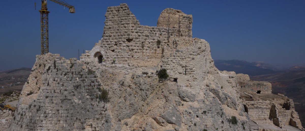
Trip 1: Tatev Monastery. Setting out from Yegheghnazdor towards Goris, you’ll get to experience the typical valleys and mountain passes that Armenian road travelers have to deal with. Tatev Monastery sits on the southern side of the wooded Vorotan Gorge.

You’ll turn south off the main M12 highway and head along the northern side of the gorge before crossing the river at Devil’s Bridge and then approaching the monastery up the other side. If you wish to save yourself a hilly switchbacked drive of about 20-30 minutes in each direction, you can stop at the Wings of Tatev cable car (https://tatever.am/en) and take that instead – the view from the 12-minute ride over the Vorotan Gorge is certainly better. Tatev monastery was founded in the 9th century and its main Sts Peter & Paul church dates from around 900. The St Gregory Church was built just south of it around , next to the separate tomb of Saint Gregor Tatevitsi. As with many old buildings in seismically active Armenia, there was extensive damage from a 1931 earthquake, since reconstructed.

Tatev Churches and St. Grigor Tatevatsi’s Tomb

If you have extra time, there is a great 7-kilometer hike between the monastery and Devil’s Bridge, a natural rock bridge over the Vorotan River that runs down the side of the gorge and along the valley floor (https://hikearmenia.org/all-trails/trail/devils-bridge).

Vorotan Gorge

You’ll need to arrange for a pickup at the other end to return to your start point.

Trip 2: Goris. Goris is an excellent town for a stopover. It’s an attractive place that sits in a wider valley area, with the medieval cave city of Old Goris nestled in the cliffsides and conical rock formations to the east of town.

Old Goris

Goris has many well-preserved classic southern Armenian stone houses, many of which are adding their traditional wooden balconies back.

It’s a pleasant town to walk round and the medieval cave dwellings of Old Goris are worth seeing – you can cross the Vararek River via the Garegin Nzhdeh Street bridge and then take a right on Satyan Street to reach the park area. You can use the Hike Armenia app to guide you – https://hikearmenia.org/all-trails/trail/time-travel-to-old-goris.

Kapan’s main Parc de Vienne square and the commercial area just north are popular gathering spots and there are a few cafes and restaurants in the immediate vicinity. You can visit the Aksel Bakunts House Museum (41 Mashtots Street), which is a well-preserved example of a traditional home and an insight into a famous Armenian writer.

Goris Logistics. Goris has a wide range of accommodation and I stayed at the Khoreayi Dzor Hotel, a modern hotel with large rooms and great views over the city – it’s a 20-minute walk to and from the center and there are also good alternatives closer in. Two good restaurants in town are the Wine Garden (65 Syunik Street), which has a large outdoor garden area and is popular for Armenian barbeque, and the Takarik Tavern (65 Syunik Street).

Classic 1960’s Russian GAZ (Gorky Automobile Factory) M-21 Volga automobile, Goris

The Cafe Tur Bazar (end of Grigor Tatevatsi Street), which overlooks the river and medieval cave complex has a good outdoor beer garden and friendly staff – try the local Goris beer, a well made malty lager.

Old Goris

Goris is the home of Armenia’s national quick dish, Jhingalov Hacs, which is a selection of fresh herbs put between fresh lavash bread and griddled. It’s delicious and meets most dietary requirements.

Jhingalov Hacs
Dowtown Goris and Police Station Emblazoned with a Former Soviet Star

Trip 3: Kapan. Kapan is a 2-3 hour drive south through the scenic Goris River gorge and Vorotan River valley. It can be a slow drive with hairpin bends, Iranian trucks and periodic rainy weather and fog. Note that certain stretches of the road lie inside the post-2020 War settlement Azerbaijani border, and that you’ll see (as of 2021) Armenian military and Russian ceasefire observers at certain points.

You can travel through in safety – applying caution for rain, fog and slow-moving trucks – but be ready to stop at the Armenian security checkpoints where they may ask to see your passport and then wave you through. If you use google maps you won’t be routed via this direct southeasterly Goris-Kapan road (and instead sent via Tatev), but ask at your hotel before you set out whether the road is open, which it was in Spring 2021.

Azeri Stretches of the Goris-Kapan Road

Kapan is a grittier working town set in the Voghji River valley, with significant industrial activity from Soviet times. You’ll see a large number of workers’ flats set into the northern hillsides overlooking the town, reflecting it’s importance as a Soviet-era industrial center.

Abandoned Ferris Wheel, Kapan Central Park

Today, it’s an important center for molybdenum mining. The Kapan History Museum (24/41 Garegin Nzhdeh Street) is worth a visit, and records the history of the 1994 Nagorno-Karabakh War, as well as the participation of Kapan’s citizens in WW2. There’s also good recording of Kapan’s development since the 19th century and as a mining center.

Kapan’s WW2 Veterans – Kapan History Museum

There are some good side trips possible from Kapan. If you’re a determined driver, you could go on to Meghri, 72 kilometers away on the Iranian border.

Russian FSB Ceasefire Patrol Vehicle, Kapan

Vahanavank Monastery is worth a look – just 10 minutes west of Kapan along the Meghri Road, this 11th century church was built by the Queen of Syunik.

Another more ambitious outdoor objective is Mount Khustrup, which can be accessed via the Baghaburj area of Kapan or via Navcha https://www.alltrails.com/trail/armenia/syunik–3/mount-khustup.

Kapan Logistics. Kapan has a few hotels in the center, and the Dian Hotel, a 15-minute walk just east of town, is modern and well-run. Cafe Elegant (32 Shahumyan Street) and Tumanyan’s (Shahumyan Street roundabout just east of Cafe Elegant) are popular restaurants. A good shwarma cafe is located just west of Cafe Elegant on the opposite side of Shahumyan Street.

Yeghegnadzor: Armenian Highlands, Hilltop Fortresses and Wine

The town of Yeghegnazdor is the capital of the central Armenian province of Vayots Dzor, a winemaking region and a good travel base south of Yerevan. Central Armenia has plenty of rugged terrain, and the roads get windy. At this point, it was worth hiring a vehicle to get about. Yeghegnazdor is less than a day’s drive from Yerevan and there’s plenty to see along the way.

Trip 1: Monasteried Out. Heading south towards Yeghegnazdor from Yerevan, you can hit up the historical sites of Khor Virap, the Garni Temple and Geghard Monastery, finishing up in Yeghegnazdor for the evening. These are all day-trip distance from Yerevan, so are better seen early in the day and best avoided over weekends, but nonetheless worth checking out. The Khor Virap (Deep Dungeon) Monastery is worth seeing in part because of its location in the plains east of Mount Ararat – arrive early because Ararat clouds up through the day. You want to catch it in the morning when it’s year-round snowy peak floats above the cloud line.

Mount Ararat and Lada Niva 4×4

Garni Temple. Heading southeast from Yerevan, the first stop is the Garni Temple, a Roman-era basalt temple originally constructed in about 170 AD in memory of the Romanized ruler of the Province.

It sits above the Azat River Valley and is co-located with a 7th-century Christian church. Demolished by an earthquake in the late 17th century, it was only restored in the early 1970s.

Azat River looking East

Geghard Monastery. Further east, you can also see the Geghard (Spear) Monastery, another iconic Armenian religious center, partly built into the cliffside and with cave dwellings and rock-hewn chapels in the cliffs above the complex. Founded in the 4th century around a Spring overlooking the Azat River gorge, the main chapel was built around 1215. There are active churches within the walled monastery complex, with the main Katoghike Chapel quite busy on a Sunday.

Katoghike Chapel Vestry

Khor Virap. The Khor Virap monastery was the place where Gregory the Illuminator, the first leader of Armenian christianity, was imprisoned for 12 years before he began converting the monarchy and population to Christianity. You can visit his 3rd-century dungeon – grab the safety line and take it carefully down the stairs. The current buildings are more recent, from around the 17th-century. It’s better to go early in the day to be able to see Mt. Ararat, just over 30 km to the west, before the peak clouds over.

Khor Virap

Trip 2: Yegheghis Village and the Jewish Cemetery. Armenia is located in a tough geopolitical neighborhood with challenging mountain terrain. The village of Yeghegis is located in the verdant Yeghegis River valley, a state wildlife sanctuary, and has been settled for thousands of years. The original medieval town is closer to the river than the current town and has one of the oldest known Jewish cemeteries from around the 13th-15th centuries. It has a cluster of churches, notably the Zorats (Army) Church just east of town, built in 1303. It has a terraced outdoor gallery so that arms and horses could be blessed before battle, along with their riders.

Zorats Church

If you head just east of town and take the first right-hand vehicle track, you go south towards the river and cross it on the footbridge that leads to the medieval Jewish cemetery (https://goo.gl/maps/yw1NcpwTYDQmUJJX8). Believed to be one of the oldest Jewish cemeteries identified outside the Middle East, there are about 60 medieval headstones from a period when the region was ruled by Mongol and Turkic invaders. Many of these are elaborately ornamented and inscribed.

Yeghegis Jewish Cemetery

Yeghegis village can be a prelude to the next trip, but it makes for an ambitious day.

Trip 3: The Smbataberd Fortress and Tsakhats Kar Monastery Hill Hikes. This is an approximately 4-5 hour out-and-back hike that takes you to the impressive hilltop fortress, named after Prince Smbat, the regional ruler of the time, and then via a high meadow to the monastery, which is about 2 kilometers east of the fortress via a vehicle trail. As also used here (https://www.aerotrekka.com/armenia-hiking-the-caucasus/), the trusty HIKEArmenia.org website and app provide a useful downloadable hiking map. https://hikearmenia.org/all-trails/trail/tour-through-wine-country

Smbataberd Fortress Looking South

Smbataberd Fortress. You can either start this trail from Yeghegis Village to the south, or approach from the next valley over, from the west, via the village of Artabuynk – you’ll see the hiking app displays both approach routes. I visited Yeghegis Village first, left my Lada Niva safely parked in the center and took the gradual path up to Smbataberd, which you can see from the start of the trail.

Yeghegis Village from Smbataberd Fortress

Once you’re at Smbataberd, for which the outlines of the outer walls, entrance tower, keep and certain inner walls remain, you can see how this dominated the valleys off to either side of its clifftop redoubts. Largely built by Armenian rulers around the 9th-10th century, the fortress was lost to invading Seljuk Turks in the 11th century, with the legend that a thirsty horse discovered the water pipe supplying the fortress – leading down from the monastery – which was then cut.

Smbataberd Fortress looking northeast towards Tsakhats Kar Monastery

Tsakhats Kar Monastery. After checking out the fortress, and wondering how anyone moved around these hills with medieval military equipment, you then head northeast down the vehicle track into a meadow – grazing cattle may be around – and then up the hillside towards the windswept Tsakhats Kar monastery complex, almost 4 km northeast.

Tsakhats Kar Monastery

This consists of two chapels built in the 11th century; the eastern Holy Cross and western St. John the Baptist churches. The monastery complex has great views looking south and over Smbataberd and has elaborate carved designs on its facade and on the standing stones (khachkars).

St. John the Baptist Church
Holy Cross Church

A large ruined monastery building is located along the road track about 150 meters west of the two churches, with an intact doorway, front wall and standing archways. This appears to have been built between about 1000 and 1200, and would have been a substantial center for the time, notable for being in such an isolated spot. The weed-filled open area inside the walls is filled with stones, khachkars and a water trough.

Logistics. I stayed at the Green Stone Hotel (https://goo.gl/maps/3QbhQDmNP5kDGTsy8 2, 5, Gladzoryan Lane), which is a new and very comfortable small hotel, equipped with a garden and swimming pool. Food options in town are mainly via the local hotels and B&Bs, which are very high quality with plenty of fresh local produce. You should try to book dinner the day before.

Green Stone Hotel Balcony

The Green Stone Hotel has great catering, and the Old Bridge Winery (https://www.oldbridgewinery.com) offers an extensive Armenian set menu with their own wines. A good casual option and popular stopoff is the Food Court, which offers a typical Armenian menu and is located on the Yerevanyan Highway heading southeast just out of town (https://goo.gl/maps/oSrWVvr5252myBMu6).

Wineries. You should do your winery research before you go. Armenia and Georgia have a healthy debate as to who has the oldest winemaking tradition, although Armenia’s wine industry is at a smaller scale given that many vines were given over to brandy production in the Soviet era. There are nonetheless plenty of quality wineries that focus on some of the 31 wine grape varieties found in Armenia, like the Areni (red), Kangun (white) and Voskehat (white). Vayots Dzor hosts the annual Areni Wine Festival every May and there are plenty of nationally recognized wineries in the valley, including Hin Areni, Momik, Trinity Canyon, Yacoubian and Zorah.

Car Hire and Roadways. Your car hire choices are mainly located in Yerevan. I went with one of the local providers, Car&Van (https://www.caravan.am/en-home.html), who usually have the option to hire a Lada 4×4, pictured earlier in front of Mt. Ararat. The Lada lacks the comforts and ergonomics you usually expect and is a dated design with an upper speed limit of about 80-90 km/h. However, the suspension and clearance are well suited to many of Armenia’s roads, particularly outside and south of the Yerevan area. Once you’re clear of Yerevan, specifically when you turn off the main H8 highway to head east to Yeghegnadzor, nearly all roads are single-lane each way and degraded in places, so figure on a typical road speed of between 50-80 km/h.

Winding Roads and Iranian Tanker Trucks

Armenia’s sole north-south road between Yeghezhnador and the Iranian border at Meghri runs through the towns of Goris, Kapan and the hill ranges and associated hairpin bends along the way, so it’s a careful drive along with the Iranian lorries. Given the incidence of potholes and roadworks, you should avoid driving in the dark.

Tsakhats Kar Monastery Entrance