Hokkaido is Japan’s northern island, and Rishiri is where you go if one island isn’t enough. Located on Japan’s northwestern tip along with it’s flatter sister Rebun Island, Rishiri is a forested dormant volcanic cone, accessible by ferry from Wakkanai, Japan’s most northerly city. Mt. Rishiri is a popular and quite challenging hike peaking at 1,721 meters above sea level, and there is a bikes-only road for 20 km around the north coast.
Oshidomari Port
You can fly into either of the airports serving Rishiri or Wakkanai, however there is frequent rail service from Sapporo via Asahikawa to Wakkanai, with onward ferries to the islands. Once you dock at Oshidomari after a 100-minute ferry ride, it’s usually a 30-minute or so walk to one of the pensions or hotels in town. Most of the pensions offer an early morning minibus ride to the Mt. Rishiri park trailhead, as well as a packed lunch. If you start your hike early (04:00-05:00) you’ll be under the cloudbase for most of the ascent. The round-trip hike will take 7-9 hours depending on your fitness level, so in most cases you will be done by mid-afternoon. You will need to stay at least one night on Rishiri in order to wake for an early start, and while there is a late afternoon ferry back to Wakkanai, a second night allows time for a hot spring and further exploring.
The Mount Rishiri Hike
The most main trailhead starts just south of the tarmac road leading south from Oshimodari and is clearly signposted. You start at the visitor center and pass a small temple on the initial trail.
Once you break out of the forest on the lower slopes, the mountain side is mostly covered in waist-high scrub or open areas. The fog will start to break at the lower levels so that you can look down on the port.
Oshidomori Port and Pon-yama Hill from Rishiri Mountain
The peak trails are very well marked and signposted, with periodic distance markers, although rocky and steep in places, so take hiking poles if you like your sense of balance untipped.
The trail posts are a useful progress guide – #8, shown below, is at about 1,200m. Official hiking season starts in July; while the summer weather is humid, an early start avoids the increased temperatures from late morning onwards.
Peak from Trail Post 8
The entire trail is walkable and the steep sections can be done without needing to scramble. The last stretch has rope guideways to keep you away from the side of the trail, which is eroded in places.
There is a small shrine at the peak from which you can contemplate mortality and the steep sides of Rishiri Mountain.
Mt. Rishiri is defined as an ultra-prominent peak and you have a clear view of the surrounding countryside below, despite a persistent marine fog layer over much of the lower island.
On clear days you can see Hokkaido and Sakhalin but otherwise can contemplate the lower cloud layer over the Sea of Japan. Closer in, the return trail from the peak is mostly soil and grit, and you should follow the rope guides to avoid adding to the erosion.
Once you have completed your hike, it’s another mile or so along the road back to Oshidomori. The Rishirifuji Onsen, a hot springs (onsen) bath house with indoor and outdoor hot springs (https://maps.app.goo.gl/fHWNxBvQWHK1MKWL7) is on the road back and worth a visit.
A rather neat approach to steep trail erosion devised by the national park is to fill and stack large plastic drums in order to provide a stable set of steps over the sharp inclines. They are very walkable and much safer than trying to deal with a steep crumbling dirt and rock slope.
Drum Staircase, Peak Area Trail
Logistics
Accommodation
I went in August and given tight availability had to book each of two nights at different but adjacent pensions, Rera Mosir (http://www.maruzen.com/tic/oyado/index.html) and Green Wind (http://greenwind.sakura.ne.jp). Both were comfortable places with an excellent seafood dinner and a choice of a packed lunch or Japanese breakfast as part of the booking.
Menu at the Rera Mosir Pension
There aren’t many restaurants on Rishiri but the pension restaurants take pride in their local produce and are excellent. If you are looking for lunch, Warakaudo is a good Chinese restaurant (https://maps.app.goo.gl/msZKR9j578CtJxjd7). The pensions have outdoor gear to rent and will take you to the Mt. Rishiri trailhead or to the ferry terminal. I booked both through their websites and you will need to have one page open translated to your preferred language and the original that you work on (Pro Tip: when filling out booking details on Japanese websites, if you are asked to enter your name in Japanese kanji script, and do not have a Japanese name, drop your name into Google translate to get the literal Japanese transliteration, and use that). If you need to pick up last minute provisions for the outdoors, there is a Seicomart convenience store in town.
Getting There and Back
Heartland Ferry (http://www.heartlandferry.jp/english/) offer multiple daily sailings between Wakkanai and Rishiri (Oshidomori port), with a 1 hr 40 minute journey time. You can also tag on Rebun island as part of a larger itinerary. You can book seats in advance or just turn up on the day – there was spare capacity on my Thursday and Saturday sailings.
Japan Rail Hokkaido (https://www.jrhokkaido.co.jp/global/index.html) operate rail services on the island, and trains to Wakkanai operate via Asahikawa. It’s about 5 hours between Hokkaido and Wakkanai and the train journey gives you a good feel for the Hokkaido landscape.
Wakkanai
Wakkanai is a convenient overnight stop before getting a morning ferry to the islands. Take-chan Izakaya (https://take-chan.co.jp/en/) is a very popular seafood restaurant.
Take-Chan Izakaya Menu
The Dormy Inn and Surfeel Hotel are two good accommodation options that are a short walk from the ferry terminal. The railway station is in the immediate center and only 5 minutes walk from the ferry terminal.
You don’t associate the Yucatan peninsular and it’s east coast beach resort strip with city visits, but the Yucatan’s major pre-tourist era cities of Merida, Campeche and Valladolid can easily occupy a week of your time without needing a car.
They are all walkable cities linked by an excellent bus network, and side trips to the world class Maya archaeological sites of Uxmal and Chichen Itza are easily arranged. It’s worth noting that Maya culture and language is still alive and well despite Spanish colonization, with about 800,000 Yucatec Mayan speakers.
Merida
Merida! One of Mexico’s largest preserved colonial cities and the capital of Yucatan State.
Rectory of Jesus, Merida
Merida retains its low-slung colonial street pattern (odd-numbered streets – calles – run east-west, even north-south) with the usual main plaza surrounded by colonnaded businesses, one of the Mexico’s oldest cathedrals (built 1561-98) and a governor’s palace. On the south side of Plaza Grande, visit the Casa de Montejo (1542) a mansion built for the Spanish governor’s family, now open as a museum.
Parque de Hidalgo
You can spend plenty of time covering the city center streets largely bounded by Calles 50-68 east-west and Calles 55-65 north-south. Check out the main markets in the center, particularly Mercado San Benito (Calle 69 at Calle 54) and the Mercado Municipal #2, which has a range of good food vendors. (Calle 57 at Calle 70). Parque de Santa Lucia (Calle 55 at Calle 60) is a popular gathering place in the evenings.
A walk along Paseo de Montejo north out of the old center is lined with various 19th/20th century mansions. Merida’s Regional Anthropology Museum (Calle 43 and Paseo de Montejo) is housed in the Palacio Canton, a former Governor’s residence, and well worth a stop for its exhibits on regional Maya discoveries. Further north (a taxi ride from the center), the newer Museum of the Maya World (http://www.granmuseodelmundomaya.com.mx/) is a good preparation for visits to the Maya sites.
Mansion, Paseo de Monteo
If you are after a traditional Yucatan jipijapa hat, the local version of a Panama hat, go to El Sombrero Popular (Calle 65 #32 west of Calle 54). It’ll keep the sun off better than a baseball hat.
Merida Side Trip – Uxmal and Kabah
Uxmal (Oosh-mahl), the Yucatan’s second largest Maya complex after Chichen Itza, is 80 km south of Merida and a very practical day trip. It is estimated to have been founded around the 6th century AD as the Puuc region capital, that covered other smaller sites including Kabah, Labna, Sayil and Xlapak. Uxmal was abandoned in the mid-10th century after military defeat by forces from Chichen Itza.
Uxmal View looking North from Governor’s Palace – Ballcourt in Foreground, House of the Magician at Right
The site is relatively small (700 x 800 meters) and a visit starts through the House of the Magician Temple, a series of five pyramidal temples built over each other in the 6th-9th centuries. Remember that Maya buildings were often painted, with temples usually in red.
House of the Magician Temple
You then pass into the Nunnery Quadrangle with its raised rectangular buildings, before climbing up to the Governor’s Palace, on a raised area with an ornately carved frontage.
Nunnery QuadrangleGovernor’s Palace
Kabah
Kabah is usually visited as part of the Uxmal daytrip. It was a smaller Puuc center about 18 km south of Uxmal, originally connected to Uxmal by a causeway. Developed earlier than Uxmal in about the 3rd century AD, it was also abandoned in the 10th century. There aren’t any major surface rivers in the Yucatan, and so the Maya were dependent on naturally occurring sinkholes (cenotes) or wells, topped up by periodic rainfall, for which they prayed to Chaac, a rain god shown here in the form of a serpent. Kabal has no cenotes and so would have been reliant on wells.
Palace of the Masks
You’ll start at the Palace of the Masks, with a facade covered in over 300 masks of Chaac. The repeated pattern is unusual for Maya structures, and would have been even more impressive when the serpent’s noses were intact and the facade painted. Nearly all of the hooked and curled serpent’s noses have broken off but you can see some intact ones to the right of the temple facade.
The back of the temple has two very rare human guardians – the Atlantes – not commonly seen on Maya temples, one wearing a jaguar head dress.
As you enter the rear area, you’ll see some very well preserved carvings depicting scenes of ornately dressed warriors in combat.
The final main site to see is the raised palace, which has many intact details.
Kabah Palace and Forecourt
I booked with Edith’s Tours (edithstoursmerida@gmail.com) who covered Uxmal and Kabah.
Kabah Palace
Valladolid and Chichen Itza
Valladolid gets a bit ignored as a destination, in part because it’s a mid-point between Merida and Cancun, but it’s a nice town with a busy main square. It’s also the closest large town to the Chichen Itza site, 41 km away or about 40 minutes drive.
Templo de San Servacio
If you prefer to avoid group tours, it is also very simple and quick to catch a collectivo minibus to Chichen Itza. If you go early, you can see Chichen Itza (allow 2 hours onsite) while it’s cooler and before the major crowds turn up from Cancun.
Parque Principal, Valladolid
Valladolid was founded in 1540, with the main church built in 1545. It’s a very pleasant town for walking around and the Mercado Municipal is worth a look. Also, walk along the more historical Calzada de los Frailes to see the Parque Sisal and the Convent of St. Bernard of Siena, opened in 1560, which was built over a cenote.
Convent of St. Bernard of Siena
Valladolid Side Trip – Chichen Itza
Chichen Itza is the largest Maya site in the Yucatan, and was the principal city from its founding by the Itza ethnic group, around 600AD, through to its conquest in the 13th century. Chichen Itza can be roughly translated as the Mouth of the Well of the Itza, with there being at least four cenotes on the site. The major and final development of the city that we see today occurred at the peak of its influence in the 10th century.
KukulcanTemple with Serpent Guardians
The first stop is the 30-meter high Kukulcan Temple, built in various phases in the 8th-12th centuries and dedicated to Kukulcan, a plumed serpent deity, whose head stands at the foot of each stairway balustrade. During Fall and Spring Equinoxes, the shadows of the pyramid steps create an impression along the balustrade of a serpent descending the pyramid.
Great Ball Court
Next up is the Great Ball Court, the largest in Mesoamerica, set amongst a complex of other temples.
Skull Platform
Some areas of the park are allowed to mix with foliage, giving an idea of how Chichen Itza must have looked like on its rediscovery.
The Group of a Thousand Columns, just south of the Temple of the Warriors, consists of the remaining columns supporting a roofed complex.
Temple of the Warriors and Group of a Thousand Columns
Campeche
The capital city of neighboring Campeche State is a very well preserved fortified seaport. Established in 1540, the city was repeatedly attacked by pirates and was sacked in 1663. The Spanish administration constructed a major city wall in the late 17th century that included a fortified port area. 12 major sections of the fortress wall strongpoint bastions (the baluartes) still stand, enclosing the city’s grid street pattern.
Baluarte de la Soledad
Campeche became a quiet backwater after independence, and while the oil industry has brought prosperity to the region, its former neglect led to remarkable preservation.
Some of the baluartes are now local museums, with Museo de la Ciudad (Baluarte de San Carlos) on Av. de 16 Septiembre being the most extensive.
Plaza de la Independencia
The Mansion Caravajal (Calle 10 #230), a Governor’s mansion now converted into a government building, is worth a brief visit for its well preserved interior. Campeche’s State Government buildings echo Brasilia’s concrete brutalist, including a space ship representative chamber.
Campeche State Congress Building
Campeche Side Trip – Fort de San Jose
Fort de San Jose was constructed in the 18th century to support the city of Campeche. Situated on a hill to the northeast (https://maps.app.goo.gl/1ZHAa153rX1EtK619), it’s a short cab ride or a decent walk and provides good views over the city. The fort also contains the regional archaeological museum, with emphasis on more recent marine recoveries.
Logistics
Getting There and Around
The Yucatan is very well served by air with Cancun having substantial non-stop service, although Merida’s airport has excellent frequencies via regional hubs and is much more central once you’ve arrived. For around the region, intercity buses operated by ADO are very comfortable and timely (https://ado.reservatickets.com). The ADO intercity terminals are quite walkably central to the old towns in Merida (Calle 69, #554) and Campeche (Calle 46, #198H), but at Campeche is located a taxi ride outside the old town. The Transporte Colectivo minibus station in Valladolid for Chichen Itza is centrally located at Calle 59 between Calles 46 and 48 – buy your round trip ticket at the desk and wait for the next departure, which goes when there are enough passengers.
Merida
Merida has an excellent choice of accommodation at your preferred pricepoint, including some historical B&Bs. La Chaya Maya is perhaps the longest established Yucatan restaurant in town and is worth a visit – the Calle 57 at Calle 62 location is the original, with a newer and rather grander “Casona” location in a colonial mansion at Calle 55 at Calle 62. Other places that worked out well included Taquería de la Unión (Calle 55 #488) and Café la Habana (Calle 59 #511).
Parque de Santa Lucia
Even if it’s just for a drink and snacks, ensure you visit La Negrita Cantina (Calle 62 at Calle 49), a very lively bar restaurant with live bands most nights. Craft beer is increasingly popular in Mexico, with Bacab Cervecaria (Calle 56 #472) brewing a nice range of great beers; Apóstol Tap Room (Calle 55 opposite Parque de Santa Lucia) has a great selection. I also stayed at the Hotel Gran Real (Calle 56 at Calle 55), which was modern and very comfortable, and at the Hotel Boutique La Misión de Fray Diego (Calle 61 #524), which was a converted monastery with simple rooms.
Valladolid
Valladolid has developed as a low-key urban destination in it’s own right and so has plenty of good small-scale accommodation in the center. I stayed at the Casa San Roque Valladolid (Calle 41 #93), which was a really nice small hotel with a pool. Pak’al (Calle 39 #194 ) and El Sazón de Valladolid (Calle 41 east of Calle 50) are good Yucatan restaurants and there are a variety of quicker places around the intersection of Calle 32 and Calle 37 just southwest of the Mercado Municipal. There are a variety of restaurants and bars along Calzada de los Frailes – Mezcaleria Don Trejo has a nice outdoor area and Los Frappes (overlooking Parque de Sisal) is a popular bar/restaurant.
Valladolid Center
Campeche
Campeche is an important regional center and you can pick from newer hotels just outside the old town to smaller places in the old city. I stayed at the Gamma de Campeche Malecon which was a decent newer hotel just north of the Baluarte de la Soledad. There are plenty of restaurants and bars along Calle 57 to choose from, although La Parroquia (Calle 55 #8) is a great local standard and La María Cocina Peninsular (Calle 8 #103) is a higher end place. Santo Taquito (Calle 57 #14) is a great taqueria in the old town and there are a bunch of taquerias in the Mercado Campeche just southeast of the old town.
Penang is Malaysia’s largest island with its capital, Georgetown a remarkably preserved Asian trading city. One of three Straits Settlements (the others being Malacca and Singapore) carved out for direct rule in the British colonization of Malaysia, Penang grew as a seaport, trading and financial center. As its economy grew, Penang became a popular destination for Chinese immigrants from the Pearl River Delta in the late 19th century. Unlike Singapore, much of Georgetown’s center avoided the wrecking ball of the 1970s and 1980s, in part owing to rent controls that limited redevelopment. Commercial rejuvenation in the 2000s supported preservation of its architectural heritage, with UNESCO World Heritage status achieved in 2008. Penang is one of the largest Asian cities with a pre-WW2 architecture substantially intact.
Penang is typical of many multicultural East Asian port cities, with significant Malay, Chinese, Southern Indian, Eurasian and expat communities. It’s a notable center of the Peranakan community, made of up Intermarried Chinese and Malay families – you’ll see reference to the Babas (male Peranakans) and Nyonyas (female).
Nyonya Costumes, Peranakan Mansion
You can build a walking itinerary around the various temples, some of which (near Lebuh Armenian) allow admission, such as the Yap Kongsi, Teochew Buddhist Temple, Leong San Tong Khoo Kongsi and the Hainan Thean Hou Temple.
Hainan Thean Hou Temple Doorway Carving
It’s worth staying in the very walkable and shophouse-lined older part of Georgetown, which runs southwest from the colonial Fort Cornwallis and Government buildings that surround the Padang, a grassy parade and sports ground.
Buddhist Monk Alights from Cycle TrishawKapitan Keling Mosque
Fort Cornwallis and the Padang
This area marks the original British settlement, where Penang was bought from the Sultan of Kedah by the East India Company in 1786. The fort was originally a wooden stockade that was rebuilt in its current moated brick and stone version in 1810. The fort never saw action but served as an administrative center, with a lighthouse added in the late 19th century. The museum has a range of Dutch East India Company cannons (look for the VOC label) from the early 17th century that were seized in various conflicts.
Dutch East India Company Cannon, early 1600s
The colonial administrative buildings, built in the late 19th and early 20th centuries, are now local government buildings and public spaces.
City Hall (1903)
Peranakan Mansion
This opulent townhouse was built for a Baba business leader and founder of the city of Taiping, Chung Keng Kwee, around 1895 and is well worth the visit. There is an adjacent temple dedicated to his family that has been extensively renovated. The building fell into disrepair but was acquired in the 1990s and developed as a museum for the Peranakan culture.
Reception Room
There are frequent guided tours that you don’t specifically book for, but can enquire about on entry or just wait in the main entrance foyer.
Central Atrium
The mansion is a top-20 Asian tourism destination, used as a set for and popularized by the Singaporean Mandarin Chinese language television series The Little Nyonya. It’s a popular destination for people to hang out in period dress and be photographed. http://www.pinangperanakanmansion.com.my
Chung Keng Kwee Temple
The tour includes the adjacent family temple which is quite elaborate and contains an altar dedicated to the Chung family.
Another historical mansion, the Cheong Fat Tze mansion (the Blue Mansion), is also open to the public https://www.cheongfatttzemansion.com and is a very comfortable B&B. You can also see a set of mansions built along Jalan Sultan Ahmad Shah, west of the old town, and eyeball the abandoned Runneymede Hotel, which was the alternative luxury hotel in the early 20th century.
Little India
Penang’s Indian community centers on a few blocks around King and Penang streets east of Chulia Street. There are also a set of Hindu temples in the area that are worth a look.
Other Ideas
Penang National Park (Taman Negara)
A short ride to the northwest side of the island, this seafront jungle park is a good escape from the city. You can head out to Muka Head lighthouse or go for a swim at one of the beaches.
Penang Hill
Penang’s hilly hinterland (https://www.penanghill.gov.my/index.php/en/attractions) is worth a visit for some rainforest hiking or to stay in one of the lodges, some of which were originally built for the British in the 19th century as a retreat from the heat and humidity at sea level (https://www.penanghill.gov.my/index.php/en/attractions/accommodation). A funicular railway (busier on weekends) goes from Air Itam to Bukit Bendera (Flagstaff Hill), which tops out at 2,450 feet. You can also hike up to the Middle and Upper funicular stations from Air Itam to the south or from the Botanical Gardens/Municipal Park (both worth a stroll themselves) to the east. There are multiple trails to choose from, including the Heritage Trail (shorter but harder with more stairs), the Penang Hill Trail (starting near Penhill Condominium in Air Itam) and the Moon Gate Trail starting from the Botanical Gardens https://penanghill.gov.my/hikingtrails/. There are multiple nature walk trails from around the Upper station, mostly in the 1.5 – 3 km distance range. If you do the uphill hike, it’s best to do so earlier in the morning, and you could buy a ticket down on the funicular if one hike is enough.
Hainan Thean Hou Temple
Logistics
Getting There and Around
The quickest and simplest way to arrive is to fly in, with plenty of connections from Kuala Lumpur as well as multiple daily flights from regional hubs like Singapore and Bangkok. There is rail service around Malaysia via a ferry or bus to Butterworth train station. Be careful of the intercity bus to Kuala Lumpur as the highways can get very congested, especially on weekends, and the bus schedules do not reflect this. Taxis are plentiful around the island and the Grab app is used in Malaysia.
Accommodation
Hotels and B&Bs are plentiful and high quality; there are multiple B&Bs converted from Peranakan mansions that are worth a look. I stayed at The George Hotel which was very comfortable. If you want a break from George Town, additional to Penang Hill, the Batu Ferringhi beach area on the north of the island has a concentration of hotels. You could also visit the waterfront Eastern & Oriental Hotel (built 1885) for it’s colonial-era vibe.
Yeng Keng Hotel
F&B
Macalister Signature Food Court
Penang is highly regarded for its South East Asian and Indian food, often gathered into hawker centers. There are plenty of Nasi Lemak and Nasi Kandar restaurants where you can pick from a range of sides to go with steamed rice.
Durians!
A few extensive hawker centers include New World Park (Swatow Lane and Jalan Hutton), Macalister Signature Food Court (105 Jalan Macalister), Anson Road Market Food Court (Jalan Seang Tek just south of Jalan Anson). The main things to look for are dry and wet noodle dishes as well as rice and side combos; Char Kway Teow is perhaps the flagship noodle dish, with your choice of protein options. The Singaporean local food blog Makansutra has some good tips for eating out in Penang: https://makansutra.com/penang-not-just-about-char-koay-teow/
Laksa
There aren’t a lot of places serving satay, a Malaysian barbeque, but AK Satay is great (on Lebuh Presgrave near Lebuh McNair). Some good local Peranakan restaurants include D’Dapor (147 Jalan Hutton) and Jawi House (85 Lebuh Armenian). Southern Indian food is another rich environment – try Woodlands Vegetarian (60 Lebuh Penang), Muthu Banana Leaf (153 Lebuh Acheh) and Kandy (119 Jalan Penang). Woodlands has great masala dosa and coffee for breakfast. Fu Er Dai (7 Jalan Sultan Ahmad Shah) has great dim sum.
Yap Kongsi Temple, Lebuh Armenian
Penang’s nightlife is quite lively, in part being a diverse port city that caters to a significant year round tourist market. Good places to find casual outdoor bars are Chulia Street between Lebuh Cintra and Love Lane, and the surrounding area; and around Armenian Street. Momokaka (48 Lebuh Armenian) is a local craft brewery that also sells a good selection of regional beers.
Alexandria is the Mediterranean’s largest coastal city, set along a curving bay and well worth a visit to see its its Greek, Roman and European past. Founded by Alexander the Great in 331 BC as the capital of Ptolemaic Egypt, the city is his last known resting place, where we was brought after his death in 323 BC. Besieged by Julius Caesar in 47 BC during the Roman Civil War, Alexandria was under Roman control from 30 BC after Cleopatra VII, the last Ptolemaic ruler, was deposed.
Falling under the control of Byzantium in 395 AD after the collapse of the Western Roman Empire, Egypt was conquered by the Arabs in 642 and by the Ottoman Empire in 1519.
Corniche
Egypt gained effective independence in 1840 from the Ottomans under Muhammed Ali, an Albanian-born Ottoman Governor who seized power and mobilized the Egyptian Army, now considered the founder of modern Egypt. Mohammed Ali and his successors reformed and modernized the Egyptian Government and economy, with Alexandria notably adopting a more European format from the mid-19th century onwards; occupied by Britain between 1882 and 1952, the city consolidated its role as a major port, naval and industrial center.
Alexandria experienced substantial Greek immigration in the 19th and early 20th centuries, was the home of the poet Constantine Cavafy and the subject of Lawrence Durrell’s Alexandria Quartet of novels. It’s an easy 3-hour train ride from Cairo and very walkable once you arrive.
Fisherman’s Beach
Apart from strolls along the waterfront and in the sidestreets behind, the main things to see include the Qaitbay Citadel, a 15th century Mamluk Sultanate fortress guarding the bay; the Kom el Shoqafa Catacombs, stunning 2nd-century underground burial chambers that reflect Greco-Roman Alexandrine beliefs; some great Egyptian-Roman archaeology museums; and a visit to the recently re-opened Library of Alexandria.
Waterfront Cafe and Qaitbay Citadel
There are also interesting street markets in the area west of Ahmed Oraby Square, although most of the side streets behind the Corniche are packed with small shops and busy. Alexandria feels very safe and lived in, but as ever take the same precautions that you would at home.
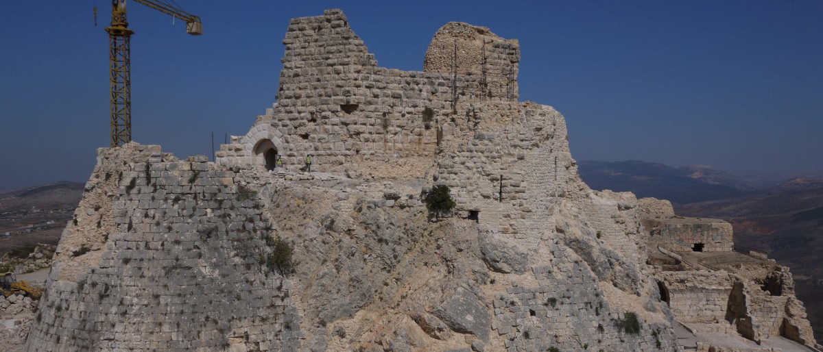
Qaitbay Citadel
Built under the Mamluk Sultanate in the late 1400s to defend against an increasingly aggressive Ottoman Empire, it is located on the site of the famously ruined Lighthouse of Alexandria.
Alexandria Bay View from Qaitbay Citadel
The Citadel has two sets of walls surrounding the courtyard and central keep and contains a mosque and a prison. It was periodically modified through to the early 19th century, but was heavily damaged by the British invasion in 1882.
Kom el-Shuqafa Catacombs
Carved out of rock between the 1st-4th centuries AD, the three-level passages and chambers of the catacombs were used for burial ceremonies and interment and reflect the merging of Egyptian, Roman and Greek religious influences amongst the Alexandrine elite. At the entrance, a circular staircase takes you down to a reception area and then to the tombs. The central main tomb is adorned with superbly preserved wall carvings that represent Egyptian deities, such as the jackal-headed Anubis, protector of graves and embalmer, dressed as a Roman soldier, standing over a mummified body.
The catacombs – called the Mound of Shards in Arabic, were covered over by the discarded shards of eating and drinking vessels – were rediscovered around 1900. Of all the sites, see this one first thing in the morning – the tour groups start turning up mid-morning and pack the place out.
The main tomb entrance is flanked by an Agathos Daimon, a Hellenic household god who was adopted as a protector of the city.
Agathos Daimon
Be sure to see the Tigran Street tomb, located in the garden above the catacombs, which was moved here from the eastern part of Alexandria. This is a 2nd-3rd century AD Roman tomb that was originally underground. The main fresco shows the deceased flanked by the Egyptian goddesses Isis and Neftis.
Tigran Street Tomb
After seeing the catacombs, you can walk to the nearby Serapeum, which contains a fairly ordinary set of Greco-Roman ruins and a single red Aswan granite column from Pompey’s era.
Archaeology Museums
Alexandria’s principal archaeology museum, the recently renovated and comprehensive Greco-Roman Museumhttp://www.alexandria.gov.eg/Alex/english/Graeco%20Roman%20Museum.html, covers the Greek, Roman and Coptic eras. Largely containing exhibits recovered locally, it is an essential stop.
Apis Bull, Greco-Roman MuseumMedusa Mosaic, Greco-Roman Museum
Just east of the Greco-Roman Museum is the Alexandria National Museum (https://maps.app.goo.gl/MGRxtdPHMzYhRoPh8) located in a 1920s-era mansion. Ensure that you catch the Egyptology display in the basement.
Finally, the Roman Theater, located just north of the main railway station is worth a quick visit.
Library of Alexandria
Roman Alexandria’s two most iconic landmarks, the lighthouse (in 956 AD) and the library (in 48 BC), were both destroyed by earthquake and fire respectively. There are few indications as to the grandeur of classical Alexandria beyond reconstructions of the city plan. The library was built on the waterfront to serve as a modern data repository and knowledge center.
Western View of Ancient Alexandria from Greco Roman Museum
The library, built in 2002, is worth a visit and apart from quietly wandering its beautiful reading rooms, check out the various side exhibits, ranging from Islamic art to a museum commemorating Anwar Sadat.
Other Options
Alexandria is a convenient jumping-off point for western Egypt, including the desert battlefield of El Alamein. You can take the train to the famous railway station and work it out from there, or get a guided day-tour.
Note that while most of the online-available tours visit the military museum and Allied and German/Italian military cemeteries, they don’t visit the battlefield itself.
Logistics
Getting There
Take the train from Cairo Ramses II railway station; to locate the foreigners’ ticket office, you’ll need to go up the escalators in the main hall and take a left on the upper floor. They take credit cards and a one-way (early 2024) first class ticket was US$26. Egyptian National Railways don’t accept online bookings for foreign visitors so factor in time to buy your ticket first.
Ramses II Rail Station, Cairo
On arrival at Alexandria’s central railway station you walk for about 15 minutes up Al Naby Danyal Street to the waterfront hotels.
If the train doesn’t appeal, a one-way taxi/ride-hail app ride between the cities is about US$50, which is very reasonable for what is a 2.5 hour ride. While the Uber and Careem ride-hail apps work in both Cairo and Alexandria, the inter-city price quoted may be unreliable; be prepared to have the driver try to negotiate directly when he turns up.
Getting around Alexandria, most locations are walkable and for taxis the Careem app was reliable and very affordable – tip heavily.
Egypt has visa issue on entry for most passports; if you want to save some time on arrival you can get an e-visa in advance at https://visa2egypt.gov.eg/eVisa
Accommodation
You can take your pick of the early 20th-century hotels clustered by Saad Zaghloul square by the waterfront. I stayed at both the Cecil and the Metropole; both were very traditional spaces evocative of the era, amenities upgraded and very comfortable.
The Metropole has a nice rooftop restaurant that works well for breakfast or an evening beverage, and was where Cavafy kept an office.
View from the Metropole Rooftop
Eating Out
There are plenty of great seafood restaurants in town, as well as typical Arab offerings. The Greek Nautical Club (https://maps.app.goo.gl/xt9aeMe2ZSFuG1Mz6), located just south of the Qatbay Citadel, is higher-end and serves alcohol.
There are plenty of traditional “European” cafes evoking the turn of the 20th century that are worth a stop, including the ornate Cafe Trianon next to the Metropole Hotel; the Cafe de la Paix on the waterfront boulevard; Farouk Café 1928, and Sofianopoulo Coffee Beans, a long-standing Greek-owned coffee shop.
Most visits to Estonia include time in Tallinn with a side trip to Tartu or the western islands. These are all good ideas but there is a lot more to see of Estonia’s busy history and wooded eastern expanses. A hire car is essential to be able to travel readily although the distances are not great.
Main Stops on the Route Source: Google Maps.
Cold War Islands
Saaremaa is Estonia’s largest island, and was a major Soviet Cold War defensive site with restricted entry during the Soviet occupation. The Sorve Peninsular has a series of sites from the Cold War and it’s an easy day trip south of Kuressaare.
Traditional Windmill, Saaremaa
Taking a counterclockwise route round the peninsular, you pass first through the site and memorial of the Battle of Tehumardi, where in October 1944 advancing Soviets – largely consisting of recently conscripted Estonians – encountered a German blocking position. A confused night battle led to the German withdrawal south until they evacuated for East Prussia and further defeat. Today it’s a partly reforested area running down to the sea, with a Soviet memorial and military cemetery.
Soviet War Memorial (1967), Talamudi
Driving further south will take you to the abandoned missile base at Maantee (https://maps.app.goo.gl/3pLnvfLQwdzjBK7h6) with its dingy abandoned Soviet administrative blocks.
There are random observation posts dotted around the coastline, where many a Soviet conscript spent a freezing and pointless night looking for incursions.
The southern tip of the Sorve peninsular has a good local Cold War museum (https://www.visitestonia.com/en/sorve-museum) that houses wartime and occupation artefacts as well as random military items recovered locally.
Northwest of the Sorve museum along the coast road is the Stebeli Battery (https://maps.app.goo.gl/qJWEohHVpQzDiHsA6), named for the Russian commander who commanded it during the German October 1941 invasion. There’s a memorial and a multi-level command bunker (enter at your own risk), but the twin artillery pieces have long since been removed.
Kuressaare is an excellent base from which to cover the island. It’s superbly preserved 17th-century castle, dominating the small town harbor, is worth a visit and set in a large park. There is a set of modern “spa hotels” just south of town that offer clean rooms and solid breakfasts – I stayed at the Meri which worked out great. There is a good choice of pubs and restaurants within walking distance along Tallinna road.
Kuressaare Castle
Road Tripping Estonia
Unless you are heading in and out of a city in rush hour, or on the main Tallinn-Riga/Narva highways, Estonian roads are largely quiet – more so if you cut across the country. Driving east from Kuresaare, you can stop at Viljandi for its castle ruin overlooking the local lake, and a history that largely consisted of being in the center of various conflicts from the 17th century onwards. Kohvik Fellin (Tasuja pst 1, Viljandi) is a good lunch stop.
From there it’s a short drive to Tartu, Estonia’s second city, main university town and home of the Estonian independence movement. It’s a good stopover and worth a visit in it’s own right, more details here https://www.aerotrekka.com/tartu-time/.
From Tartu, you can drive along Lake Peipsi, which takes up much of Estonia’s eastern border with Russia. Lake Peipsi is a popular summer destination but can be appreciated for it’s desolation in the winter.
Lake Peipsi
You can drive up along its northern side until you reach the border village of Vasknarva, which overlooks the Narva River and has a small castle ruin. After that, head through the forest to Johvi and join the road to Narva. Stalinist-era architecture enthusiasts should consider a pause at the planned 1950s city of Sillamae, built on the site of a popular 19th century seaside resort (Tchaikovsky visited) and then industrially repurposed for oil shale and uranium processing.
Castles Galore
Estonia has had the experience of being located in a region contested by German Balts, Poles, Swedes and Russians, as reflected in the number of fortifications covering various strategic points. The otherwise drab post-Soviet border town of Narva – pulverized in the 1944 battles and functionally rebuilt – offers Narva Castle, a huge and well-preserved largely 15th/16th-century castle that gives you a view of the corresponding Ivangorod fort on the opposite side of the River Narva, as well as the auto queue into Russia. The castle has a well-laid out tour guide, and after taking in the large courtyard and grounds (look for the statue of Lenin, pointing East, located in a maintenance yard), you can go up the main Herman Tower for views into Russia.
Ivangorod Castle, Russia
From Ivangorod, St Petersburg is a 160-kilometer straight shot, but you should take your visitor dollar impact elsewhere.
Ivangorod/Narva Border Crossing and City of IvangorodLenin amongst the Blocks
From Narva Castle, take the footpath north under the road bridge and walk along the riverside walk, made up from bastions built by the Swedes to (ultimately unsuccessfully) protect from Russian invasion.
Narva Bastions and Ivangorod
From there, you get a good view of Ivangorod across the river. On the road back to Tallinn, Rakvere is a good stopover, with its own 13th-century castle.
Rakvere Castle
Logistics
As ever, I recommend a Bradt Travel Guide whenever available – they do a great job covering smaller countries, especially when you want to see more than the main attraction. Kuressaare is a good base from which to explore Saaremaa and similarly Tartu for the east.
Traveling to Estonia’s western islands by car requires ferry tickets – it’s worth booking ahead online at https://www.praamid.ee/en/homepage/ once you have your arrival time at the ferry dock worked out.
Northern Spain’s side of the Pyrenees mountain range has a wealth of scenic and challenging hiking trails. The GR11 “Senda Pirenaica” hiking trail and its north side French counterpart, the GR10, provide a complete Atlantic to Mediterranean crossing for the ambitious and backpacked hiker, supported by a series of lodges. For those looking to mix up some outdoor with other activities, it is very straightforward to pick a base town and head out on day hikes. Here are a few ideas.
Pick a Park
Spain maintains a series of national and regional parks along the south side of the Pyrenees. Two that provide a range of environments in the central Pyrenees are the Ordesa y Monte Perdido National Park (review here: https://www.aerotrekka.com/hiking-spanish-pyrenees-ordesa/) and the Aigüestortes National Park and Estany de Sant Maurici (https://parcsnaturals.gencat.cat/en/xarxa-de-parcs/aiguestortes/inici/ and https://www.vallboi.cat/en/aiguestortes). In both cases, a hire car works best to access the trailheads, although note that vehicle entry inside the Aigüestortes park is restricted to buses and taxis. There is an excellent topographical map produced by Mapas de Espana that you can download and which provides trackable navigation.
Aigüestortes National Park
The Aigüestortes (Twisted Waters) National Park is a 3-hour drive northeast from Zaragoza. I stayed in the town of Erill la Vall, one of a set of towns in the Vall de Boi, on the west side of the park. You can also access the Estany (lake) de Sant Maurici region of the park via the town of Espot from the east side.
Estany Xic
The park is a set of high, rugged lake-filled valleys and navigation between the lakes is well signposted. The two west side trails covered here have public parking, although the Vall de Boi is well served by public transit and taxis.
Estany Xic to Estany Negre Trail looking South
Presa de Cavallers – Refugi Ventosa i Cavell Trail. This is a scenic and rocky out and back hike to the Ventosa i Cavell refuge, that overlooks Estany Negre (Black Lake), a 9-km. round trip with a 350m climb up. Driving in on the L-500 via the Caldes de Boi park entrance, you start at the dam at the south end of Cavallers Reservoir, walk north along its east side, and then enter a meadow before climbing past the Riumalo waterfall.
Cavallers Reservoir looking South towards Dam
This is a very rocky trail which makes for slower going, and hiking poles come in handy for the balance challenged. The trail is however well marked, and where the path is less clear and winding between rocks, look for wooden stakes with yellow paint.
View Northeast across Meadow towards Riumalo Waterfall
The view over Estany Negre from the refuge is very impressive.
Estany Negre – View Southwest from Refugi Ventosa i Cavell
Once at the refuge, you could then hike out to some of the surrounding lakes – Estany Xic is the closest. You can park at the Presa de Cavallers parking lot below the dam, which is a popular day hike starting point.
Estany Negre and Trail to Riumalo Waterfall
Sant Nicolau River Trail to Aigüestortes Plateau. This is a more gradual and wooded dirt trail out and back along the Sant Nicolau River to the Aigüestortes Plateau, a 12.6 km round trip with a 430m climb. You can park at the La Molina parking lot (https://goo.gl/maps/qEF3SfuNdqWgzvHk8), just off the L-500 road, about 6 km north of Barruera.
Trailhead Map
The hike starts out on a steady wooded uphill trail along the north side of the Sant Nicolau River. You can return along the south side for some variety – note this trail intersection on the way out where you take the left trail over the river following signs for the Aigüestortes Plateau – the right trail fork is where you will be returning from on the way back.
You’ll pass the 12th century Sant Nicolau chapel shortly before reaching Estany de Llebrata, the one lake along the route.
Sant Nicolau Chapel
The trail runs along the north side of Estany de Llebrata before crossing over the tarmac service road and then taking another uphill push past the Sant Esprit waterfall to the plateau, located in a large wooded valley.
Estany de Llebrata looking East
The Aigüestortes Plateau has an overlook platform at Sant Esprit, restrooms and a park information center. It’s also a popular pick up/ drop off point for the bus and taxi services should you wish to go further into the park or to be collected from a cross-park hike.
Aigüestortes Plateau
On the return trail, hike back the way you came and then turn onto on the tarmac road running along the north side of Estany de Llebrata. At the west end of Estany de Llebrata, look for a trail and a river footbridge going left from the road. This trail, the Ruta de la Lludriga, climbs uphill onto an open hillside before heading southwest. You have good views over the Sant Nicolau river valley to your right, before dropping down to rejoin the main trail at the intersection mentioned earlier.
Ruta de Lludriga looking SouthwestSant Nicolau River
Other Trails
The trails described here barely cover the extensive network available to the determined hiker and summarized here: (https://parcsnaturals.gencat.cat/en/xarxa-de-parcs/aiguestortes/gaudeix-del-parc/guia-de-visita/itineraris/ or https://www.vallboi.cat/en/rutes). Other great hikes in the Aigüestortes park, include a continuation trail from the Aiguestortes Plateau east to the Estany Long Refuge and Ernest Mallafre Refuge. Further south of the Sant Nicolau River, there is another recommended trail that runs between Taill and Estany del Pesso. Also recommended is a shorter loop trail from Durro village, the Durro wildlife route. The Boi valley also has a number of Romanesque churches (https://www.vallboi.cat/es/romanic) from the 11th-12th centuries that have hikeable routes. If you are coming to the park from the east, you could base yourself at Espot and explore the trails from the Sant Maurici lake side.
Logistics
Both parks maintain useful websites and you should also download the Mapas de España app, produced by the Centro Nacional de Información Geográfica, which provides high-resolution topo maps with GPS based tracker to assist navigation. There is a park office in Boi at (Carrer els, Carrer Graieres 2 https://goo.gl/maps/2P1YQiBsNVWM4Tux8) and a regional tourism office in Barruera (Passeig Sant Feliu, 43), that hand out trail maps and can advise on the latest local transportation options around the park.
You can access trailheads inside the park via scheduled summertime bus service or the Vall de Boi Taxi Association (https://www.vallboi.cat/en/how-arribe).
Santa Eulalia Church, Erill la Vall
I stayed at the Hostal La Placa in Erill la Vall, which worked out well with comfortable rooms and a good breakfast. There are plenty of hotel options in Boi and Taull across the valley, and you can also stay in Barruera, which is the main town serving the valley. Barruera also has the only gas station – fuel ahead of entering the valley as it isn’t open all the time. There are plenty of year-round restaurant options, try El Caliu Taull (Carrer de Freixanes 11, Taull) or Ca de Xoquin (Placa Major 1, Durro). Barruera has a number of cafes and restaurants, and a good craft beer bar (La Birra es Bella, Passeig Sant Feliu 35).
Northern Spain’s side of the Pyrenees mountain range has a wealth of scenic and challenging hiking trails. The GR11 “Senda Pirenaica” hiking trail and its north side French counterpart, the GR10, provide a complete Atlantic to Mediterranean crossing for the ambitious and backpacked hiker, supported by a series of lodges. For those looking to mix up some outdoor with other activities, it is very straightforward to pick a base town and head out on day hikes. Here are a few ideas.
Pick a Park
Spain maintains a series of national and regional parks along the south side of the Pyrenees. Two that provide a range of environments in the central Pyrenees are the Ordesa y Monte Perdido National Park (https://www.turismodearagon.com/en/ficha/ordesa-y-monte-perdido/) and the Aigüestortes National Park and Estany de Sant Maurici (https://www.vallboi.cat/en/aiguestortes). In both cases, a hire car works best to access the trailheads, although note that in the Summer season and Easter holidays, vehicle entry at Ordesa is restricted to buses (https://ordesabus.com) provided into the park from Torla. There is an excellent topographical map produced by Mapas de Espana that you can download and which provides trackable navigation.
Ordesa National Park
The Ordesa National Park is a 2-hour drive northeast from Zaragoza. I stayed in the town of Torla, on the west side of the park, which has plenty of accommodation options and good restaurants, as well as a park visitor center (https://www.ordesa.net/oficinas-informacion/) where you can pick up a trail map. There are plenty of trailheads around the park perimeter.
Refugio de Goriz. I started with one of the most popular, straightforward yet visually impressive hikes, along the roughly east-west Ordesa Valley, from the Pradera parking lot to the Cola de Caballo waterfall and then to the Refugio de Góriz, 11.6 km away and almost 1,000 m up.
This is a full day out and back hike. The main trail starts out east along the Ordesa Valley with a steady climb through the woods on the north side of the Araza River. There is the option to take the Senda de los Cazadores trail which runs along the southern edge of the valley – watch for the signpost taking you right at the east end of the Pradera parking lot, where you cross south over the river. This trail has a steeper start so is better done going east, with the return along the main trail.
River Araza looking west
The main trail ascends past a series of minor waterfalls – the Cascada del Estrecho is worth a break – until the valley opens out into a high meadow that is well occupied by the local cattle and their bells.
Upper Ordesa Valley looking east
You hike along this meadow trail until you reach the Cola de Caballo waterfall, a popular climbing location.
Cola de Caballo Waterfall
Taking a right over the footbridge at the base of the waterfall, you’ll find a trail intersection that leads you on zigzag paths up the east side of the valley wall to the head of the valley, and then north to the Goriz Refuge. The trail narrows as it goes up the side, with some steep sections (hiking poles will help) but little exposure.
At the top of the trail, the Ordesa Valley lies beneath you.
Head of the Ordesa Valley, Ordesa National Park
It’s another steady uphill hike to the refuge. More ambitious multi-day trekkers can use this as an overnight.
At my moderate pace, this was about 4 hours from the Pradera parking lot to the Refuge and the same back. The Senda de los Cazadores trail was closed for repairs as of May 2023 but may well be open for the summer season.
Puerto de Bujaruelo. Another interesting trail that starts out from the San Nicolas de Bujaruelo Refuge, a 9-km drive north of Torla, which takes you north east to the French border on the GR-T 30 trail.
Trail Map for the San Nicolas de Bujaruelo Refuge
From the refuge parking lot, you cross the River Ara over the stone bridge and head northeast uphill, following the signs for the Puerto de Bujaruelo, at the French border. You can also head northwest along Bujaruelo Valley on the signposted Santiago de Compostela pilgrim trail.
Bride over the River Ara
The top of the initial climb gives great views over Bujaruelo and the ranges to the west. The Otal Valley, shown below, is another, flatter hiking alternative west of the Bujaruelo Refuge.
View West from GR-T-30 Trail to Otal Valley
The snow in Mid-May was still present along the trails leading east along the Barranco de Lapazosa, up to the pass. From the Puerto de Bujaruelo, you can head for the Sarradets refuge and the Breche de Rolande, or into the Gavarnie valley. You could also take a counter-clockwise loop via the Bernatuara Lake and Sandaruelo Refuge to return to the Bujaruelo Refuge.
View east towards Puerto de Barajuelo
Other Trails
There are other great hikes in the Ordesa park, including the north-south Aniscio Canyon, accessible from the south of the park at San Urbez church (off the HU-31 highway, parking at La Tella). This wooded trail runs along the Bellos River to Fuen Blanco, from where you can connect with a trail to the Goriz Refuge or to the Pineta Refuge – which is road accessible if someone can collect you.
Logistics
Both parks maintain useful websites and you should also download the Mapas de España app, produced by the Centro Nacional de Información Geográfica, which provides high-resolution topo maps with GPS based tracker to assist navigation.
Torla
The Ordesa Valley hike parking lot (La Pradera) is closed to private vehicles in the Summer, Easter and October bank holiday, replaced with bus service from Torla per the https://ordesabus.com website.
At Ordesa, I stayed at the Hotel Edelweiss, which was a comfortable family-run place with good breakfasts. La Cocinilla is a great place for dinner, and the El Taillon Pizzeria is a popular local bar/restaurant with good salads and pizza. You should ensure you stock up on your hiking essentials – water, snacks etc – at a supermarket on the drive in to Ordesa. There are supermarkets in Ordesa but they respect local opening times.
The Saxon German city of Dresden sits astride the Elbe River as it flows north from the Czech Republic. Saxony was one of the largest German kingdoms pre-unification and its capital Dresden was developed substantially in the 17th and 18th centuries. The city center was destroyed by Allied bombing towards the end of WW2, but was restored to something close to its baroque glory postwar. Dresden is a very liveable city, located just downriver from the Saxon Switzerland National Park and conveniently a 2-hour train ride from either Berlin or Prague.
Holy Trinity Cathedral
Much of your time can be spent visiting the restored relics of the Saxon past in the Altstadt (Old Town), located on the south bank of the Elbe. A raised promenade, the Brülsche Terrace, originally built in the 1730s, lines the central south bank. To the north, the Neustadt (New Town), so called because it was a newly developed suburb in the 18th century, is a more compact urban area for general wandering around. Less damaged after 1945, it also has a high proportion of baroque style buildings. The north bank of the Elbe is a popular place to find a spot on the grassy riverside park or a seat in the beer gardens, and enjoy the Altstadt view.
Brülsche Terrace and South Bank of the Elbe
Much of the restoration has left these buildings somewhat adrift in a more modern setting. If you wish to visit the palace complex, you can start with the pavilioned gardens of the Zwinger Palace, built in the early 18th century during the reign of Augustus the Strong, contains the Old Masters Picture Gallery and other museums. Just east is the Royal Palace (Residenzschloss), which contains Augustus’ restored palace, built around 1719.
The Frauenkirche is perhaps Dresden’s most symbolic building, compact and with an unusually high dome that dominates the skyline. Built in the early 18th century, it was an expression of baroque religious design until it’s destruction by incendiary bombs in 1945. Left as a pile of burnt rubble throughout the time of the German Democratic Republic as a symbol of Dresden’s destruction, after reunification it was gradually rebuilt (1994-2006), using the original plans from the 1720s.
Frauenkirche
For another perspective on Germany’s past, take the tram out to the Military History Museum, Olbrichtpl. 2. https://www.mhmbw.de
The Albertinum on Tzschirnerpl. 2 is well worth a visit for its striking collection of modern German art held in the New Masters’ Gallery, with a comprehensive 20th century collection. Otto Dix’ War Triptych is notably grim. Dix, a WW1 veteran and later a professor at the Dresden Fine Arts Academy, until he was sacked as a “degenerate artist” by the Nazi regime in 1933, hid the painting after its Berlin exhibition in 1932.
The War, or Dresden Triptych (1932)
There are plenty of remnants of German Democratic Republic (GDR) architecture and public art, particularly in the more modern section south of the river and towards the main railway station. The Kulturpalast, opened in 1969, is an example of a GDR public and cultural space.
Kulturpalast Mural, Rosmaringasse
Dresden was the home to Victor Klemperer (1881-1960), a professor of Romance languages at the Dresden Technical Institute, who is best know for his diaries (“I Will Bear Witness” is the first volume) documenting Nazi oppression between 1933 and 1945. A Jewish convert to Protestantism, he survived extermination in part because of his WW1 combat veteran’s status and marriage, and also because he was able to flee his deportation order with the onset of the allied bombing of the city in 1945. His diaries are a worthwhile read. You can visit the Haus Klemperer, Am Kirschberg 19, the house that he built, was evicted from, and finally returned to in 1945.
One can’t visit Dresden without a small tip of the hat to Vladimir Putin and the Soviet Union with a visit to the former KGB local office at Angelikastrasse 4, where in December 1989 he and his associates burnt their files surrounded by demonstrations against the collapsing GDR. You can’t enter that building, but you can visit the Bautzner Street Memorial, the former GDR security police (Stasi) prison located around the corner at Bautzner Strasse 112a and now a museum (http://www.bautzner-strasse-dresden.de/).
Side Trips
Dresden is a great base to visit other parts of Saxony, a less visited part of Europe. The Saxon Switzerland National Park (https://www.nationalpark-saechsische-schweiz.de/?lang=en) is excellent for hiking, and can be reached in under an hour by train to Bad Schandau. To save the round trip cutting into a hiking day, you are best off overnighting at Bad Schandau, and can access the trailheads on foot from there. Leipzig is about an hour away by train and again would be full day trip unless you add it to an intercity itinerary.
Logistics
Dresden is easy to get around, with a concentrated central area and a useful tram service to get you out of the center. I stayed just east of the Altstadt at the Hofgartnerhaus at Brühlscher Garten 4. You may want to consider the Neustadt as a place to stay, with its better concentration of restaurants and nightlife, particularly on the blocks north of Bautzner Strasse. Dresden has become a popular city to live in as Berlin’s living costs have increased and the ability to work remotely is better accepted.
The Neustadt has a fine selection of beer and wine bars, some in places that haven’t changed much since the GDR, including some use of repurposed empty plots.
A few decent places include:
Bautzner Tor, Hoyerswerdaer Strasse 37, is a comfortable local gastropub with an extensive local menu and a good beer selection.
Ocakbasi, Eschenstraße 1, is a good Turkish standby.
Raskolnikoff, Böhmische Str. 34, a Russian restaurant, offers an alternative to German standards.
Zapfanstat, Sebnitzer Strasse 15, craft beer bar with their own offerings and a wide range of visiting beers.
Dresden’s main railway station is an almost 30-minute walk to the Altstadt, and there are regular trams that run there and into the Neustadt. To get set up with local transit tickets (not available on the tram, unfortunately), look for the DVB logo, or check out their website https://www.dvb.de/en-gb/tickets-en/tourists-en
Tarragona is located on Spain’s southeast coast between Valencia and Barcelona. It’s defendable hill location overlooking the ocean made it an attractive base for the Roman invasion of Spain in the 3rd Century BC. Founded around 218 BC as Tarraco by the two Scipio brothers, both Roman generals, it was Rome’s first major city in Spain and became one of the principal capitals of Roman Hispania, and was the base for Julius Caesar’s victory over Pompey in 49 BC, who declared Tarraco a colonia, the highest status of a Roman city. It’s a popular day trip from Barcelona but with extensive Roman artefacts, a compact medieval center and walkable beaches, it’s really worth a few days of your time.
Colonia Iulia Urbs Triumphalis Tarraco: The Roman City
Praetorium and Roman Circus
The extensive remains of the Roman circus and forum area are the main attraction. These were built in the 1st Century BC and later built over by the Visigoths and then the medieval Crown of Aragon as the core fortified area. To orient with the reconstruction picture below, you enter the circus at its lower right (southeast) corner and move north along the original Roman passageways into the lower right of the forum building.
Roman Circus – East Passageway
Tarragona’s fortress core, built up over the Praetorium Tower, sits on this area. The Roman city wall shown at the top left of the picture also remains and we’ll see that later. The oceanside amphitheater is located to the southeast and can be visited separately.
Museum Exhibit – Roman Circus, Forum and Temple Complex above the Lower City
From the passageways that bordered the amphitheater and forum, you then move up into the Praetorium, a military tower that was extended in the 12th century by the Crown of Aragon. The southerly facing view in the photo below captures the curved eastern side of the circus and shows the original Roman access passageway that ran along the east side of the circus building – now topped off by the medieval Torre de los Monges in the southeast corner.
Southeast Section of Roman Circus and the Torre de los Monges
Looking north from the Praetorium tower, you can see the old city and medieval cathedral – built from the late 11th century and consecrated in 1331 under the Crown of Aragon, which included Catalunya. The cathedral sits over the site of Roman temples (seen top center in the city illustration above), including the main Temple of Augustus, and was preceded by a Visigothic cathedral destroyed in the Moorish invasion.
Tarragona Cathedral – View from __ Tower
There are other Roman sites around the city – in addition to the amphitheater, the forum site, located at Placa del Forum, is one of the main gathering places in the old city. Further south in the lower town (and just south of the central market hall), the Colonial Forum, built in 30 BC, is worth a visit. Also, the Roman city wall that is largely intact along the northwest to northeast of the old city. Finally, the National Archaeological Museum provides an overview – although was closed for remodeling as of summer 2023. Walks around the old city reveal Roman structures and the occasional inscription. With the decline of the Roman empire, Tarragona was occupied by the Visigoths in around 476 AD, who ruled it until the arrival of the Moors in around 713 AD.
Roman Circus – North Terrace looking West
The Roman Wall
The Roman Wall, located in the Archaeological Park (Passeig Arqueologic), runs over a kilometer from the northwest to northeast sides of the old city, with residences built into the inner side. The perimeter was originally established in 217-197 BC, before being built up into more extensive fortifications around 150 BC. You can see the difference between the original large blocks and the smaller and more regular stones and brickwork of the later fortification. The upper works were added to in the medieval era under Aragonese rule, and an outer bastion was built in the 18th century. The current park walkway is between the Roman wall and the outer bastion.
The wall is one of the few intact continuous sections of Roman fortification outside Italy and was originally 3,500 meters long – total demolition was prevented by designation as a cultural site in 1884.
Tarragona Cathedral
The plain facade of the cathedral – more ornate development was halted in 1348 by the effects of the Black Death – reveals an ornate Gothic interior, including the high altar from around 1430 dedicated to St. Thecla.
The cathedral also contains the tomb of James of Aragon – the eldest son of James II, King of Aragon, who renounced his right to the throne to become a monk.
There are a series of mid-15th century tempura paintings, uncovered in the 1930s.
There are various chapels built over the life of the cathedral, including the Cardona Family chapel from around 1520, with panels depicting scenes from the life of the Virgin Mary.
Port and Beaches
If you have some spare time left over from the old city, a walk to the old Port area along Moll de la Costa and the fisherman’s Serrallo neighborhood, is in order. There are two main beaches in the city, with Platja Arrabassada, to the north, being the more scenic, located in a bay between two wooded headlands.
Logistics
I stayed at the Hotel Astari (Via Augusta, 95), recently renovated and a 5-minute walk from the old center. If you come by train, note that the fast inter-city trains usually call at the Camp Tarragona station, 14 kilometers north of town. There are frequent 20-minute bus services between Tarragona’s central bus station (https://empresaplana.cat). The best food options are in the old town and around the central market – southeast of the market, La Mossegada is great for lunchtime tapas.
La Mossegada – Cuttlefish on the Grill
The old town’s main square, Placa de la Font – really a rectangle – is an excellent place to have an early evening drink and soak in the sandstone. There are plenty of good food options around Placa del Forum and the streets leading into it, including La Vermuteria del Forum, El Galliner de Antiquari and Toful Forum. Further south in the old town, Lo Cat (Carrer d’en Vilarroma, 10) is a great seafood restaurant, and the Serallo neighborhood by the old port has a cluster of seafood places. Twins Craft Beer (Carrer del Trinquet Vell, 21), overlooking a section of the Roman circus terrace, is a good craft beer bar, and Domum (Plaça de la Font, 13) has an extensive Belgian beer selection.
Absolutely goddamn right. Northern Thailand offers hilly tropical park and riverside vistas to the itinerant traveler as well as being a convenient riverine link to Luang Prabang in Laos. Chiang Mai is a popular hub for visitors although if you want a quieter venue head northeast for Chiang Rai. From there you can head towards Thailand’s hilly frontiers with Myanmar or Laos. Thaton is one border center at the top of the country, across from Myanmar.
Tha Ton and the Kok River looking towards Myanmar
The Kok River, a tributary of the Mekong River that flows from the Myanmar highlands via northern Thailand into Laos, is the most direct and traditional route between Chiang Rai and Tha Ton.
Leaving Chiang Rai. Chiang Rai is a laid back regional center that’s worth staying for a day or two. You should make sure to see the Baan Dam (Black House) Museum, 11km north, a complex of traditional houses filled with exhibits created by the artist Thawan Duchanee.
Baan Dam Museum Main Building
Another attraction is the contemporary and ornate all-white Wat Rong Khun (White Temple), 13 km south of town. To depart Chiang Rai, you can book a longtail boat by calling the ferry service owner at +66892700869, or you can book via the very helpful Government tourism office located inside Chiang Rai Bus Terminal 1, located on Prasopsook Road downtown. The one-way boat rental cost was ฿2,500 (about US$70) – the scheduled service offered in the reverse direction (Tha Ton – Chiang Rai) wasn’t available at the time. Ferries depart from the Cherdchai Pier terminal (here https://goo.gl/maps/K6QzSuVjNubR8QFv8) and a pickup from your hotel is included in the service. Other destination options from Chiang Rai include mixed road and Mekong River travel to the historic riverside city of Luang Prabang, Laos (visa on entry is usually available but check before you go) – many providers will arrange a through ticket.
Cherdchai Pier
The ferries are usually equipped with a lightweight roof but you are open to the elements for the most part.
The Kok River. The journey lasts 2-3 hours by shallow draught longtail boats, so called because the propeller rotates at the end of a 3-meter (or thereabouts) shaft that allows both sharp maneuver and avoidance of grounding in shallow water.
Longtail Boat on the Kok River
The middle section of the river narrows and winds through steeper passes with rock pools and whitewater rapids, which the boats deal with readily.
Most of the riverside consists of agricultural land interspaced with jungle – patches of hillside get used up.
As you get closer to Tha Ton, the winding river opens out into a wide agricultural valley with views of the northern hill ranges, that mark the Myanmar border country and are dotted with distinctive white temple spires.
Finally, Tha Ton with its monastery, temple and standing Buddha comes into sight.
Tha Ton. Tha Ton is a small border town clustered around the boat station. It has decent accommodation and the surrounding area is quite attractive for hiking and general contemplation.
Tha Ton Boat StationDoi Pha Hom Pak National Park
You can visit the Doi Pha Hom Pak National Park and hike to Huamereng Peak, or if you just want to walk or bike into the valley just head northwest from the town center along the 1314 Road which takes you into the nearby farming valleys. Closer to town are the Wat Thaton Chedi and Standing Buddha, that overlook the Kok River on its way to the Myanmar border.
Farming Village, Doi Pha Hom Pak National Park
Logistics. Tha Ton has infrequent scheduled bus service to Chiang Mai, and periodic unscheduled sangkaews (pickup trucks with covered bench seating in the back) run the 26 km to and from Fang – my morning wait by the police station at Tha Ton bridge took 45 minutes. From Fang bus station, there are frequent long-haul bus and minivans going to Chiang Mai and Bangkok. In Tha Ton, I stayed at the Maekok River Village Resort which was comfortable and a mile east of town along the Chiang Rai road. Should you wish to return to Chiang Rai by public boat service, there is a ticket office selling ฿400 tickets for the daily 12:30 departure.